Home
Weather New York
WeatherRadar
RainRadar
TemperatureRadar
WindRadar
LightningRadar
Weather News
Editor's Pick
Discover the app
Weather widget
Contact us
Apps
Career
    Home / Weather News /

    Northeast U.S. - Heavy rain poses flash flood risk

02:40 PM
March 31, 2026

Northeast U.S.
Heavy rain poses flash flood risk

Heavy rain and warm temperatures pose a flood risk.
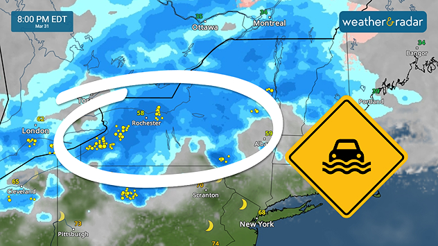
Heavy rain and warm temperatures pose a flood risk for the interior Northeast.

Heavy rain and thunderstorms have been keeping the windshield wipers active on Tuesday morning. Several rounds of wet weather plus snowmelt pose a flash flood risk today through Wednesday.

Driving in heavy rain safetyread more

Flood watches have been issued in the interior Northeast ahead of the event. Water temperatures are surging north, melting winter snow. This snowmelt, plus the one to two inches of heavy rain, poses a flood risk for low-lying areas, rivers, creeks and streams, as well as poor-drainage areas.

Tuesday morning's activity will give way to a brief break before more rain and storms move in during the mid-afternoon across the Northeast. This next round lasts well through the dawn hours of Wednesday.

Commuters should add extra time to their afternoon and morning drives to make sure they make it to their destination safely and on time. Remember, turn around, don't drown. Swollen rivers, creeks and streams sending even 12 inches of moving water over the roads can sweep a car away.

Becca Parker
More on the topic
Super Typhoon Bavi threatens Taiwan. 155 mph winds. . Weather Videos. Wednesday, July 8, 2026
The image shows an intense tropical cyclone over the western Pacific, east of Taiwan and the Philippines. The centre of the system is depicted as a light purple and white vortex with a clearly visible eye, surrounded by a ring of red and orange areas indicating the strongest wind speeds. A white arrow marks the typhoon’s predicted track towards the north-west, in the direction of Taiwan. To the west of the storm lie the Philippines, with the cities of Manila and Cebu; to the north of these lies Taiwan, with Taipei. Further west, the Chinese coast, including Hong Kong, and parts of Vietnam can be seen. The coloured wind map shows predominantly green areas outside the storm’s core, indicating significantly weaker winds. White streamlines illustrate the typhoon’s anti-clockwise circulation in the Northern Hemisphere. The highest wind speeds are concentrated around the eye of the cyclone.
Weather VideosWednesday, July 8, 2026

155 mph winds

Super Typhoon Bavi threatens Taiwan
Meteorological summer is here!. Bye, spring!. . . Monday, June 1, 2026
Monday, June 1, 2026

Bye, spring!

Meteorological summer is here!
High pressure & extreme heat. Why & how does it work?. . . Sunday, July 12, 2026
Sunday, July 12, 2026

Why & how does it work?

High pressure & extreme heat
All weather news
This might also interest you
Area to watch this weekend. Tropical trouble?. . . Wednesday, July 15, 2026
An area of low pressure is expected to develop this weekend off Florida's Big Bend. The question is: will this mean tropical trouble for the Southeast?
Wednesday, July 15, 2026

Tropical trouble?

Area to watch this weekend
Follow the clouds. High-pressure ridge. . . Monday, July 13, 2026
Monday, July 13, 2026

High-pressure ridge

Follow the clouds
Year's worth of rainfall piling up. Southwest Texas. . . Thursday, July 16, 2026
Extreme weather alerts active in Southwest Texas.
Thursday, July 16, 2026

Southwest Texas

Year's worth of rainfall piling up
All articles
Weather & Radar

Weather & Radar is also available on

Google Play StoreApp Store

Company

Contact us Privacy policy Legal info Accessibility statement

Services

Uploader

Socials

instagramfacebookthreadslinkList