Home
Weather New York
WeatherRadar
RainRadar
TemperatureRadar
WindRadar
LightningRadar
Weather News
Editor's Pick
Discover the app
Weather widget
Contact us
Apps
Career
    Home / Editor's Pick /

    Over 20 million at risk: Multi-day severe storm outbreak possible

02:49 PM
January 8, 2024

Over 20 million at risk
Multi-day severe storm outbreak possible

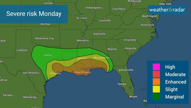
This first week back to school for many brings the chance for severe storms across the South on Monday and then over the Southeast on Tuesday. For both days combined, there are 20 million at risk of experiencing severe conditions.

The next storm system sweeps from west to east, pushing a strong cold front, increasing the chance for one or two tornado outbreaks and the potential for hail and damaging wind gusts with the storms. There is plenty of warm air channeling in with the warm front pushing north. This will prime the atmosphere on Monday and will crash with the cold front passing through in the latter part of the day, sweeping everything eastward with a line of storms - many could be severe.

Severe weather for Monday night to Tuesday morning.

Monday night into Tuesday storms

The enhanced risk, level 3 out of 5, threatens Houston, New Orleans, Mobile, Alabama through Pensacola, Florida.

The risk of severe storms starts Monday night and goes into Tuesday from Southeast Texas through the Florida Panhandle. It will likely be a line of storms barreling from the west over the southeastern portion of the Lone Star State to be first affected, then Louisiana and southern Arkansas, then Mississippi, and Alabama, ending in northwest Florida in this period.

Tuesday’s threat

The threat for Tuesday increases in size for Tuesday. Over 11 million people are at risk of experiencing severe conditions and are under an enhanced risk, level 3 out of 5, from Jacksonville to Tallahassee, extending across southern Georgia and the coast of the Carolinas. But don’t underestimate the slight risk, as large cities such as Tampa and Orlando, Florida also have a chance of getting some severe storms moving through the region after 2 p.m. ET, see our WeatherRadar.

Keep in mind that considering the system will likely grow stronger on Tuesday, there is the chance for the risk to also grow. Please stay weather aware and the “bullseye” of the most at-risk locations could be better defined later Monday or even Tuesday morning.

The main threats

These storms could produce widespread damaging winds and a few tornadoes. Hail is also a possibility. Heavy rain will be an issue on Monday for New Orleans and southern Mississippi.

Please make sure to have 3 ways of receiving weather alerts and revise your emergency plans, such as a safe place you would be in case a severe thunderstorm warning or tornado warning is issued for your location.

Our team of meteorologists is carefully monitoring the evolution of this system and will bring you frequent updates on our app and across all our social media platforms.

**This same information can be seen in Spanish, written by our bilingual meteorologists if you set our app to Spanish inside the settings option on the top right. Tell your family and friends who only speak Spanish so that they can also be informed and stay safe, please.**

Irene Sans
More on the topic
Hurricane parade in the Pacific. Karina is very strong. . Weather Videos. Tuesday, September 1, 2026
WindRadar for Friday, showing the three hurricanes – Lowell, Karina and Maria – over the Pacific.
Weather VideosTuesday, September 1, 2026

Karina is very strong

Hurricane parade in the Pacific
Hawaii's second 2026 hurricane impact. Hurricane Lowell. . . Tuesday, September 8, 2026
Tuesday, September 8, 2026

Hurricane Lowell

Hawaii's second 2026 hurricane impact
The average first frosts in the U.S.. Meteorological autumn. . . Sunday, October 4, 2026
First frosts can begin in September as autumn temps move in.
Sunday, October 4, 2026

Meteorological autumn

The average first frosts in the U.S.
All weather news
This might also interest you
Hurricane drought in the Atlantic. 352 days and counting. . . Wednesday, September 30, 2026
The last hurricane to form in the Atlantic was Hurricane Melissa on October 13, 2025, 352 days ago. So what's responsible for this hurricane drought?
Wednesday, September 30, 2026

352 days and counting

Hurricane drought in the Atlantic
Autumn foliage: weather's impact. Leaf-peeping season!. . . Sunday, October 4, 2026
Cool nights can help intensify autumn foliage color!
Sunday, October 4, 2026

Leaf-peeping season!

Autumn foliage: weather's impact
Merging storms to bring record rain. Southwest, Plains. . . Tuesday, September 29, 2026
Heavy rainfall is expected across the Plains and Southwest, with flash flooding possible.
Tuesday, September 29, 2026

Southwest, Plains

Merging storms to bring record rain
All articles
Weather & Radar

Weather & Radar is also available on

Google Play StoreApp Store

Company

Contact us Privacy policy Legal info Accessibility statement

Services

Uploader

Socials

instagramfacebookthreadslinkList