Home
Weather New York
WeatherRadar
RainRadar
TemperatureRadar
WindRadar
LightningRadar
Weather News
Editor's Pick
Discover the app
Weather widget
Contact us
Apps
Career
    Home / Weather News /

    Play Ball! Chicago could be soggy

03:31 PM
March 26, 2026

Possible Chicago trouble
Play Ball!

Could rain cause problems in Chicago

Baseball's first full day of regular season baseball kicks off with 11 games scattered across the U.S. Weather could only impact a couple games today.

The first pitch for today's first game is at 1:15 p.m. ET in New York City, where the Mets host the Pirates. The WeatherRadar shows increasing clouds, but most of the rain soaking upstate and western New York won't arrive until long after the game has concluded.

This is the same scenario in Philadelphia, where rain arrives later tonight, well after the 4:15 p.m. ET game is completed this evening.

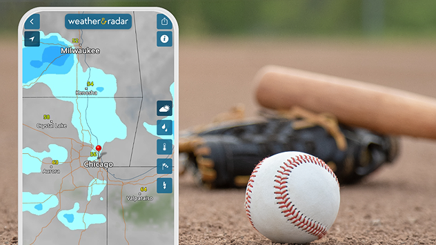
The biggest weather concern is in Chicago. Showers will be on the doorstep just as the Cubs and Washington Nationals get underway at 1:20 p.m. CT. The showers could hold off or could be just light enough to keep the game from being a washout. The WeatherRadar will be your friend if you're going to the game.

Rain is also possible in Milwaukee, but the dome will likely be closed, keeping the game from being interrupted.

The weather for the rest of today's games will be quiet. If you are going to the game, be sure to share your weather views and take Weather & Radar along.

James West
More on the topic
Super Typhoon Bavi threatens Taiwan. 155 mph winds. . Weather Videos. Wednesday, July 8, 2026
The image shows an intense tropical cyclone over the western Pacific, east of Taiwan and the Philippines. The centre of the system is depicted as a light purple and white vortex with a clearly visible eye, surrounded by a ring of red and orange areas indicating the strongest wind speeds. A white arrow marks the typhoon’s predicted track towards the north-west, in the direction of Taiwan. To the west of the storm lie the Philippines, with the cities of Manila and Cebu; to the north of these lies Taiwan, with Taipei. Further west, the Chinese coast, including Hong Kong, and parts of Vietnam can be seen. The coloured wind map shows predominantly green areas outside the storm’s core, indicating significantly weaker winds. White streamlines illustrate the typhoon’s anti-clockwise circulation in the Northern Hemisphere. The highest wind speeds are concentrated around the eye of the cyclone.
Weather VideosWednesday, July 8, 2026

155 mph winds

Super Typhoon Bavi threatens Taiwan
How does fog form?. Multiple ways. . . Saturday, July 11, 2026
Saturday, July 11, 2026

Multiple ways

How does fog form?
Super Typhoon Near the Philippines. Gusts up to 155. . . Tuesday, June 23, 2026
Tuesday, June 23, 2026

Gusts up to 155

Super Typhoon Near the Philippines
All weather news
This might also interest you
6 easy steps to take now to be ready. Hurricane preparedness. . . Sunday, August 9, 2026
Are you ready?
Sunday, August 9, 2026

Hurricane preparedness

6 easy steps to take now to be ready
When severe storms strike.... You can be ready. . . Monday, August 10, 2026
Monday, August 10, 2026

You can be ready

When severe storms strike...
The meeting of the wet masses. A Florida story. . . Wednesday, August 5, 2026
Two air masses conerge to produce storms & heavy downpours across the Florida Peninsula today.
Wednesday, August 5, 2026

A Florida story

The meeting of the wet masses
All articles
Weather & Radar

Weather & Radar is also available on

Google Play StoreApp Store

Company

Contact us Privacy policy Legal info Accessibility statement

Services

Uploader

Socials

instagramfacebookthreadslinkList