Home
Weather New York
WeatherRadar
RainRadar
TemperatureRadar
WindRadar
LightningRadar
Weather News
Editor's Pick
Discover the app
Weather widget
Contact us
Apps
Career
    Home / Editor's Pick /

    Potent Storm Ciarán - Just the start: Damage & millions without power

12:02 PM
November 2, 2023

Potent Storm Ciarán
Just begun: Damage, millions in the dark

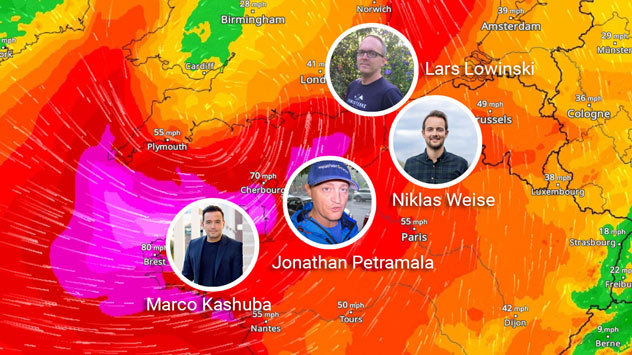
We have onsite coverage all over western Europe covering the event.

The big storm affecting western Europe is on the move. There is widespread damage across the northwestern region of France and the storm’s strong rainbands continue to sweep over the English Channel moving out of England onto France. Millions are without power.

With a five-hour difference, ahead of Eastern Time, a big chunk of western Europe is experiencing rough weather conditions this Thursday as the potent storm Ciarán moves through the region. One of the first places hit and now dealing with significant damage is the northwestern region of Brittany in France. So far, at least one person has died after a tree fell on their truck. A wind gust in this region was recorded at 129 mph. Over a million people are without power across northern France.

As the storm moved this morning over the United Kingdom, gusts over 100 mph were recorded. Many meteorologists have been watching this system as it was forecast to intensify, greatly fueled by the jetstream, located in those latitudes, and it happened overnight. Although hurricane categories are dependent on sustained wind speeds, sometimes we, meteorologists, use atmospheric pressure to match it to a category. If we were to do so with Ciarán would be equivalent to a category 3 hurricane, a big one too in size, moving through western Europe.

Residents will be hunkered down in their homes as schools, work, and businesses are closed in England, especially along the south and eastern side, as Ciarán has migrated to the east of the country.

Wind gusts in excess of 80 mph are possible for the southern coastal extremities of England, though gusts of around 100 mph are possible for the Channel Islands. These strong winds will be whipping up large waves, threatening coastal flooding.

The center of the storm will stay in the same general area over east or just east of the U.K. today and tomorrow, whirling and pushing heavy rainbands over France, Spain, and even Italy is on the board for tomorrow. Expect torrential rains and strong winds that could continue to spread damage across the continent.

We will continue to monitor this storm and bring you images and videos of what´s happening in this region of the world. Our weather reporter Jonathan Petramala is on location in northern France and will be moving with the storm to bring you the latest.

Irene Sans
More on the topic
Waterspouts possible, what are they?. They can be dangerous. . . Saturday, July 11, 2026
Waterspouts weatherradar.
Saturday, July 11, 2026

They can be dangerous

Waterspouts possible, what are they?
Super Typhoon Bavi threatens Taiwan. 155 mph winds. . Weather Videos. Wednesday, July 8, 2026
The image shows an intense tropical cyclone over the western Pacific, east of Taiwan and the Philippines. The centre of the system is depicted as a light purple and white vortex with a clearly visible eye, surrounded by a ring of red and orange areas indicating the strongest wind speeds. A white arrow marks the typhoon’s predicted track towards the north-west, in the direction of Taiwan. To the west of the storm lie the Philippines, with the cities of Manila and Cebu; to the north of these lies Taiwan, with Taipei. Further west, the Chinese coast, including Hong Kong, and parts of Vietnam can be seen. The coloured wind map shows predominantly green areas outside the storm’s core, indicating significantly weaker winds. White streamlines illustrate the typhoon’s anti-clockwise circulation in the Northern Hemisphere. The highest wind speeds are concentrated around the eye of the cyclone.
Weather VideosWednesday, July 8, 2026

155 mph winds

Super Typhoon Bavi threatens Taiwan
High pressure & extreme heat. Why & how does it work?. . . Sunday, July 12, 2026
Sunday, July 12, 2026

Why & how does it work?

High pressure & extreme heat
All weather news
This might also interest you
How does a hurricane form?. Hurricane preparedness. . . Sunday, July 19, 2026
hurricane maria
Sunday, July 19, 2026

Hurricane preparedness

How does a hurricane form?
Multi-Day flood threat for Mid-Atlantic. Stalled front. . . Wednesday, July 22, 2026
Wednesday, July 22, 2026

Stalled front

Multi-Day flood threat for Mid-Atlantic
Dry vegetation, low humidity and winds. The perfect fire recipe. . . Sunday, July 26, 2026
Sunday, July 26, 2026

The perfect fire recipe

Dry vegetation, low humidity and winds
All articles
Weather & Radar

Weather & Radar is also available on

Google Play StoreApp Store

Company

Contact us Privacy policy Legal info Accessibility statement

Services

Uploader

Socials

instagramfacebookthreadslinkList