Home
Weather New York
WeatherRadar
RainRadar
TemperatureRadar
WindRadar
LightningRadar
Weather News
Editor's Pick
Discover the app
Weather widget
Contact us
Apps
Career
    Home / Weather News /

    Prepare for dangerous weather: Stormy midweek for Plains

04:46 PM
March 3, 2026

Dangerous weather ahead
Stormy midweek for Plains

The spring storm season is slowly unfurling across the southern Plains, with a decent preview of dangerous storms on Wednesday and Thursday.

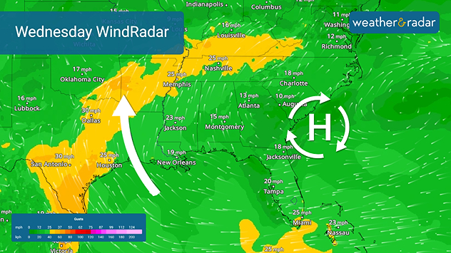
The impetus for this week's stormy weather is high pressure building over the Southeast. As the WindRadar shows, strong southeasterly winds will bring a humid airmass from the Gulf northward into the southern Plains and the lower Mississippi Valley.

The WindRadar shows high pressure over the Southeast bringing a gulf airmass.

The unseasonably warm and humid air —the TemperatureRadar shows highs in the 80s — will interact with a storm system rolling out of the Rockies Wednesday and Thursday.

The WeatherRadar shows storms developing from eastern and northern Texas northeastward into the central Mississippi and lower Ohio valleys. Wednesday's strongest storms will hit Texas, with damaging winds and large hail possible in Waco, and Dallas, Texas, and into the Ozarks and southwestern Missouri.

On Thursday, the storm threat shifts westward into western Texas and the Texas and Oklahoma panhandle. Once again, damaging winds and hail are likely.

The spring storm season will become more active this month, so now is the time to prepare. Below is a list of Weather & Radar features you should check daily for the latest storm threats:

Learn about the WeatherRadarread more
Hourly forecast: Plan with confidenceread more
Track storms with LightningRadarread more
Activate storm alertsread more

James West
More on the topic
Record-breaking heatwave in Europe. Hotter than most of U.S.. . . Thursday, June 25, 2026
Thursday, June 25, 2026

Hotter than most of U.S.

Record-breaking heatwave in Europe
Super Typhoon Bavi threatens Taiwan. 155 mph winds. . Weather Videos. Wednesday, July 8, 2026
The image shows an intense tropical cyclone over the western Pacific, east of Taiwan and the Philippines. The centre of the system is depicted as a light purple and white vortex with a clearly visible eye, surrounded by a ring of red and orange areas indicating the strongest wind speeds. A white arrow marks the typhoon’s predicted track towards the north-west, in the direction of Taiwan. To the west of the storm lie the Philippines, with the cities of Manila and Cebu; to the north of these lies Taiwan, with Taipei. Further west, the Chinese coast, including Hong Kong, and parts of Vietnam can be seen. The coloured wind map shows predominantly green areas outside the storm’s core, indicating significantly weaker winds. White streamlines illustrate the typhoon’s anti-clockwise circulation in the Northern Hemisphere. The highest wind speeds are concentrated around the eye of the cyclone.
Weather VideosWednesday, July 8, 2026

155 mph winds

Super Typhoon Bavi threatens Taiwan
Waterspouts possible, what are they?. They can be dangerous. . . Sunday, August 9, 2026
Waterspouts weatherradar.
Sunday, August 9, 2026

They can be dangerous

Waterspouts possible, what are they?
All weather news
This might also interest you
Be prepared for wildfires. By using the app. . . Saturday, August 29, 2026
Wildfires can spark anywhere, anytime. The Weather & Radar app can help you determine your area's risk.
Saturday, August 29, 2026

By using the app

Be prepared for wildfires
Taste of autumn on the way. Heatwave shifts. . . Friday, August 28, 2026
Friday, August 28, 2026

Heatwave shifts

Taste of autumn on the way
Useful tips when driving in the rain. Flood safety. . . Sunday, August 30, 2026
Sunday, August 30, 2026

Flood safety

Useful tips when driving in the rain
All articles
Weather & Radar

Weather & Radar is also available on

Google Play StoreApp Store

Company

Contact us Privacy policy Legal info Accessibility statement

Services

Uploader

Socials

instagramfacebookthreadslinkList