Home
Weather New York
WeatherRadar
RainRadar
TemperatureRadar
WindRadar
LightningRadar
Weather News
Editor's Pick
Discover the app
Weather widget
Contact us
Apps
Career
    Home / Weather News /

    Remembering the 1935 Labor Day Hurricane

07:00 PM
August 31, 2025

The strongest on record
1935 Labor Day Hurricane

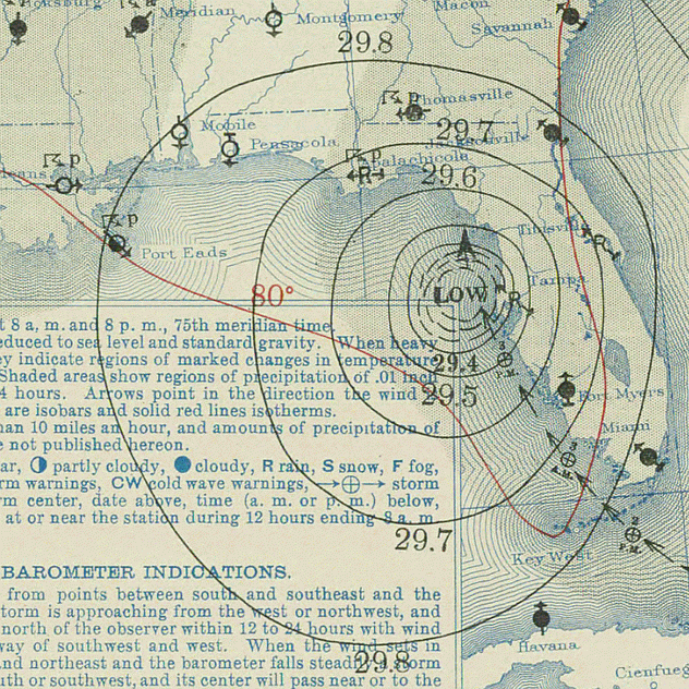
Weather Bureau surface weather map of the hurricane moving up the west coast of Florida on 4 September 1936.

While Labor Day is typically a time for barbecues and end-of-summer celebrations, it's also a poignant reminder of hidden dangers, such as the 1935 Labor Day Hurricane—the most powerful hurricane to ever strike the U.S.

The Labor Day Hurricane of 1935 was the most powerful hurricane to ever strike the United States, making landfall in the Florida Keys on September 2. With sustained winds of 185 mph and a storm surge of up to 20 feet, this Category 5 hurricane obliterated entire communities, claiming over 400 lives, including many World War I veterans working on the Overseas Highway.

The storm's rapid intensification left little time for warnings, with a record low pressure of 892 millibars recorded at landfall. The devastation prompted significant changes in hurricane forecasting and disaster response by the National Weather Service and the National Hurricane Center.

The destruction left by the Labor Day Hurricane had lasting effects, including the destruction of the Overseas Railroad and other infrastructure. Government agencies recognize this hurricane as a pivotal event that shaped future disaster response and hurricane forecasting efforts in the United States.

Weather & Radar hurricane alert systemAre your's on?
Mary Mays
More on the topic
Rip currents & safety tips. As more head to the coast. . . Saturday, July 25, 2026
rip current
Saturday, July 25, 2026

As more head to the coast

Rip currents & safety tips
Super Typhoon Bavi threatens Taiwan. 155 mph winds. . Weather Videos. Wednesday, July 8, 2026
The image shows an intense tropical cyclone over the western Pacific, east of Taiwan and the Philippines. The centre of the system is depicted as a light purple and white vortex with a clearly visible eye, surrounded by a ring of red and orange areas indicating the strongest wind speeds. A white arrow marks the typhoon’s predicted track towards the north-west, in the direction of Taiwan. To the west of the storm lie the Philippines, with the cities of Manila and Cebu; to the north of these lies Taiwan, with Taipei. Further west, the Chinese coast, including Hong Kong, and parts of Vietnam can be seen. The coloured wind map shows predominantly green areas outside the storm’s core, indicating significantly weaker winds. White streamlines illustrate the typhoon’s anti-clockwise circulation in the Northern Hemisphere. The highest wind speeds are concentrated around the eye of the cyclone.
Weather VideosWednesday, July 8, 2026

155 mph winds

Super Typhoon Bavi threatens Taiwan
Super Typhoon Near the Philippines. Gusts up to 155. . . Tuesday, June 23, 2026
Tuesday, June 23, 2026

Gusts up to 155

Super Typhoon Near the Philippines
All weather news
This might also interest you
Watch storm clusters interact. A busy WeatherRadar. . . Tuesday, August 11, 2026
Tuesday, August 11, 2026

A busy WeatherRadar

Watch storm clusters interact
6 easy steps to take now to be ready. Hurricane preparedness. . . Sunday, August 9, 2026
Are you ready?
Sunday, August 9, 2026

Hurricane preparedness

6 easy steps to take now to be ready
When severe storms strike.... You can be ready. . . Monday, August 10, 2026
Monday, August 10, 2026

You can be ready

When severe storms strike...
All articles
Weather & Radar

Weather & Radar is also available on

Google Play StoreApp Store

Company

Contact us Privacy policy Legal info Accessibility statement

Services

Uploader

Socials

instagramfacebookthreadslinkList