Home
Weather New York
WeatherRadar
RainRadar
TemperatureRadar
WindRadar
LightningRadar
Weather News
Editor's Pick
Discover the app
Weather widget
Contact us
Apps
Career
    Home / Editor's Pick /

    Risks & preparedness: Nocturnal severe weather

06:00 PM
September 5, 2026

Risks & preparedness
All about nocturnal severe weather

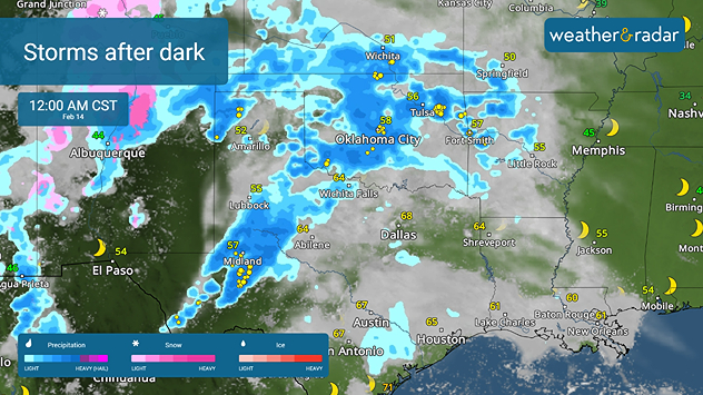
Nocturnal thunderstorms occurring in the southern Plains.
WeatherRadar: Nocturnal thunderstorms occurring in the southern Plains.

Nocturnal thunderstorms add extra dangers on top of the already dangerous weather and being prepared is important.

Nocturnal storms can be just as potent as daytime storms. However, the storms happening at night pose a larger threat – lowered visibility. This is true not only when we are asleep but also if we are traveling when these nighttime storms hit.

Tornadoes at night are more than twice as likely to be deadly as those during the day

When storms produce tornadoes, someone seeing and reporting the tornado helps spread the word to get those in danger out of the storm’s path. When it’s dark, the only way to see a tornado is if lightning brightens up the sky. How can we mitigate this issue?

Track storms in our city in our interactive WeatherMap

There is a way around this! It is important to have a way to receive warnings, even when you are asleep or traveling. Keep your notification volume turned up. Pay attention to your area’s forecast and keep your devices charged.

Additionally, a NOAA weather radio is an excellent tool to have since warnings will come through the radio alerting you to take action.

Turn on your app alertsread more

Having our weather alerts turned “on” in your app can help you stay prepared. When you receive the severe weather notification, be sure to review your emergency plan with your family before severe weather hits so that you can be prepared.

Irene Sans
Becca Parker
More on the topic
Hurricane Polo heads for Mexico. Severe weather risk. . . Monday, September 28, 2026
Hurricane Polo is set to make landfall in the Baja-California.
Monday, September 28, 2026

Severe weather risk

Hurricane Polo heads for Mexico
The average first frosts in the U.S.. Meteorological autumn. . . Sunday, October 4, 2026
First frosts can begin in September as autumn temps move in.
Sunday, October 4, 2026

Meteorological autumn

The average first frosts in the U.S.
Hurricane Polo remains dangerous. Active Pacific. . . Thursday, September 24, 2026
Thursday, September 24, 2026

Active Pacific

Hurricane Polo remains dangerous
All weather news
This might also interest you
Autumn foliage: weather's impact. Leaf-peeping season!. . . Sunday, October 4, 2026
Cool nights can help intensify autumn foliage color!
Sunday, October 4, 2026

Leaf-peeping season!

Autumn foliage: weather's impact
1,800 miles of rain. From Texas to Michigan. . . Thursday, October 1, 2026
Thursday, October 1, 2026

From Texas to Michigan

1,800 miles of rain
Rounds of rain for Florida. Not so Sunshine State. . . Monday, October 5, 2026
While October typically marks a transition to drier weather in Florida, the first full week of the month is kicking off with heavy rain. But how much rain are we talking about?
Monday, October 5, 2026

Not so Sunshine State

Rounds of rain for Florida
All articles
Weather & Radar

Weather & Radar is also available on

Google Play StoreApp Store

Company

Contact us Privacy policy Legal info Accessibility statement

Services

Uploader

Socials

instagramfacebookthreadslinkList