Home
Weather New York
WeatherRadar
RainRadar
TemperatureRadar
WindRadar
LightningRadar
Weather News
Editor's Pick
Discover the app
Weather widget
Contact us
Apps
Career
    Home / Editor's Pick /

    Several threats for Southeast: Damaging winds and flash floods

03:43 PM
May 17, 2024

Several threats thru Sat.
Southeast: Damaging winds & flash floods

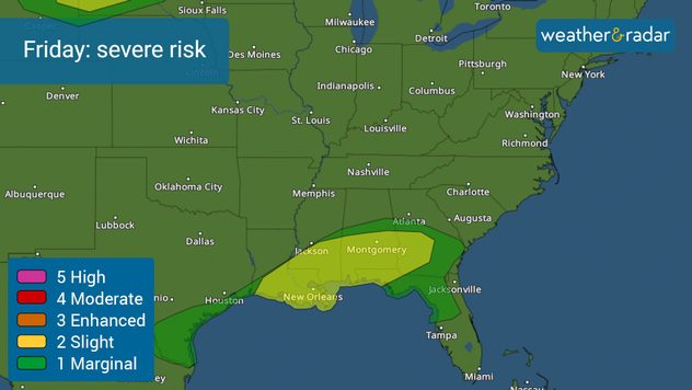
After the severe storms wreaked havoc in Southeast Texas, the system moves east, affecting southern Louisiana, Mississippi, Alabama, southern Georgia, and Florida’s Panhandle.

Severe weather risk in effect for the South.

Let’s start by saying that the risk of severe storms will be less intense over the Gulf Coast states as compared to how it was in the Houston area. Still, flooding continues to be the biggest concern, especially across southern Mississippi and Southern Alabama, as they are under a moderate risk for flash floods. Around this moderate risk, there is a slight risk of flash floods that cover southern Louisiana through much of Alabama and the western extreme of Florida’s Panhandle.

Timing

Several rounds of storms have moved in over the early morning hours as a warm front inched closer to the Gulf Coast. The low-pressure system will slowly move eastward and create more rounds of thunderstorms, some of which could turn severe during the afternoon and evening, producing damaging winds, hail, and a tornado or two. Make sure to have your weather alerts on within our app and track the storms often throughout the day. Some storms will be possible through Saturday afternoon across the Southeast as the low slowly moves east. The flooding threat will extend to the Carolinas on Saturday and even through Virginia.

Rain totals

Overall, the slow-moving low-pressure could leave 1 to 1.5 inches spread over the Southeast, but there are areas where up to 6 inches could be received. In fact, through Monday morning some of the isolated spots with the highest amounts, around 5 inches, could spread through eastern North Carolina and central Virginia.

We will be monitoring the evolution of the storm and the rounds of storms moving throughout the Southeast and continue to bring you the latest on our app and on our social media platforms.

Irene Sans
More on the topic
High pressure & extreme heat. Why & how does it work?. . . Sunday, July 12, 2026
Sunday, July 12, 2026

Why & how does it work?

High pressure & extreme heat
Longest day of the year is here. Summer solstice. . . Sunday, June 21, 2026
Sunday, June 21, 2026

Summer solstice

Longest day of the year is here
Meteorological summer is here!. Bye, spring!. . . Monday, June 1, 2026
Monday, June 1, 2026

Bye, spring!

Meteorological summer is here!
All weather news
This might also interest you
Heat indices soaring. High humidity. . . Saturday, July 25, 2026
Saturday, July 25, 2026

High humidity

Heat indices soaring
How does a hurricane form?. Hurricane preparedness. . . Sunday, July 19, 2026
hurricane maria
Sunday, July 19, 2026

Hurricane preparedness

How does a hurricane form?
Up to four feet of storm surge. Gulf Coast soaker. . . Tuesday, July 21, 2026
Tropical storm alerts are active in the app as Bertha continues to churn in the northern Gulf.
Tuesday, July 21, 2026

Gulf Coast soaker

Up to four feet of storm surge
All articles
Weather & Radar

Weather & Radar is also available on

Google Play StoreApp Store

Company

Contact us Privacy policy Legal info Accessibility statement

Services

Uploader

Socials

instagramfacebookthreadslinkList