Home
Weather New York
WeatherRadar
RainRadar
TemperatureRadar
WindRadar
LightningRadar
Weather News
Editor's Pick
Discover the app
Weather widget
Contact us
Apps
Career
    Home / Editor's Pick /

    Severe & flood risk: From the Northeast through Florida

01:51 PM
April 11, 2024

Severe & flood risk
From the Northeast through Florida

Recommended external content from YouTube

We need your consent to show content from YouTube. You can withdraw your consent at any time.
I agree that content from YouTube will be displayed to me.
Privacy policy

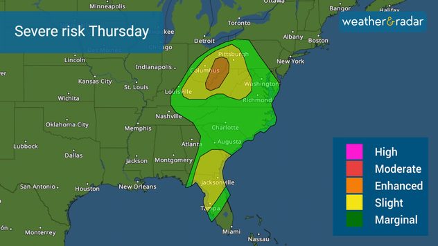
Severe weather is still on the move and Thursday's storms will take over across parts of Ohio, West Virginia, western Pennsylvania, and Kentucky. There is also a slight risk across Central and North Florida through southern Georgia.

WATCH METEOROLOGIST JAMES WEST DISCUSS THE SEVERE RISK LIVE HERE

The same complex low-pressure system and frontal boundaries are now pushing east. The center of the low will gain a bit more strength as it moves over the southern Great Lakes toward the Northeast. The cold front it drags will move over Florida and provide a one-two punch for the Sunshine State. Expect another front to finalize the shift in winds and cooler temperatures just in time to close the week and into the weekend. But first, storms are expected.

The Upper Ohio River Valley, where the center of the storm is moving through, will have a few organized severe storms that could develop tornadoes, some of which could be strong late morning through the afternoon. Some storms could also produce damaging winds and hail. Another threat will be heavy rains that could lead to flooding across the Appalachians. Flood risks extend from Pennsylvania through eastern Ohio and the mountains of Virginia through North Carolina.

Severe storms include the chance of a few strong tornadoes, especially over the Upper Ohio Valley.

The storms in Florida will also continue through the morning hours across northern Florida and Central Florida, but last through the afternoon across the Central portion of the state. Cities like Tampa and Orlando and surroundings could experience wind gusts of at least 75 mph and we cannot rule out an isolated tornado from forming.

Please make sure to pay attention to the storms and have at least three ways of receiving weather alerts. Excessive rain will be affecting much of the northern portion of Florida. The front is expected to lose its punch and get moving, so the threat of severe weather diminishes as it moves over the southern half of the state.

You may track the storms in our WeatherRadar. Our team of meteorologists is closely monitoring this storm and will continue to bring you updates on our app and across our social media platforms.

Irene Sans
More on the topic
The average first frosts in the U.S.. Meteorological autumn. . . Sunday, October 4, 2026
First frosts can begin in September as autumn temps move in.
Sunday, October 4, 2026

Meteorological autumn

The average first frosts in the U.S.
Record ocean heat halting hurricanes. Strong El Niño influence. . . Sunday, September 13, 2026
A weather map shows a calm Atlantic Ocean with no hurricanes, alongside a picture of the sea.
Sunday, September 13, 2026

Strong El Niño influence

Record ocean heat halting hurricanes
Hurricane parade in the Pacific. Karina is very strong. . Weather Videos. Tuesday, September 1, 2026
WindRadar for Friday, showing the three hurricanes – Lowell, Karina and Maria – over the Pacific.
Weather VideosTuesday, September 1, 2026

Karina is very strong

Hurricane parade in the Pacific
All weather news
This might also interest you
1,800 miles of rain. From Texas to Michigan. . . Thursday, October 1, 2026
Thursday, October 1, 2026

From Texas to Michigan

1,800 miles of rain
Hurricane drought in the Atlantic. 352 days and counting. . . Wednesday, September 30, 2026
The last hurricane to form in the Atlantic was Hurricane Melissa on October 13, 2025, 352 days ago. So what's responsible for this hurricane drought?
Wednesday, September 30, 2026

352 days and counting

Hurricane drought in the Atlantic
Merging storms to bring record rain. Southwest, Plains. . . Tuesday, September 29, 2026
Heavy rainfall is expected across the Plains and Southwest, with flash flooding possible.
Tuesday, September 29, 2026

Southwest, Plains

Merging storms to bring record rain
All articles
Weather & Radar

Weather & Radar is also available on

Google Play StoreApp Store

Company

Contact us Privacy policy Legal info Accessibility statement

Services

Uploader

Socials

instagramfacebookthreadslinkList