Home
Weather New York
WeatherRadar
RainRadar
TemperatureRadar
WindRadar
LightningRadar
Weather News
Editor's Pick
Discover the app
Weather widget
Contact us
Apps
Career
    Home / Editor's Pick /

    Severe storms on the move Rounds of damaging winds, hail & tornadoes

01:53 PM
May 14, 2024

Severe storms on the move
Rounds of damaging winds, hail, tornados

Severe storms continue tracking along parts of southern Georgia and north and central Florida. There will be several rounds of storms moving through the region with a few isolated cells over the Ohio River Valley. Let’s dive into the forecast.

A low-pressure system continues to travel just south of the Great Lakes. It is dragging several fronts which are aiding the development of storms, some severe reaching all the way into northern Florida. In the upper level of the atmosphere, there will be several impulses that will lead to several rounds of storms, some happening in the morning and afternoon and then more in the latter part of the afternoon into the evening.

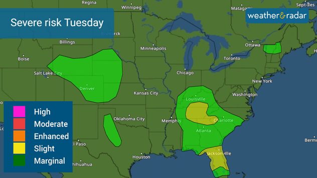
Severe risk for Tuesday brings the threat for damaging winds, tornadoes and large hail.

The slight risk, level 2 of 5 in the severity scale is focused over north and central Florida as ample moisture is in place. This afternoon, some storms could still develop damaging wind gusts, and a tornado can’t be ruled out. A tornado watch is in effect for parts of northern Florida until 1 p.m. this afternoon, this includes Jacksonville, Gainesville, and Ocala. It is possible that this threat could expand a bit more south in the coming hours and stay in effect through the afternoon across Central Florida, including Tampa and Orlando.

Across the Ohio and Tennessee valleys through northern Georgia, the storms will arrive later in the day into the evening. The storm formation will be fueled by the warming of the atmosphere during the afternoon hours, so don’t let your guard down. There could also be some damaging winds and large hail. Populated cities such as Nashville and Atlanta need to monitor the storms closely.

For the next couple of days, the severe threat remains low but present. Expect the chance for severe storms to return to Texas on Thursday with the next storm system exiting the Rockies.

We will be providing forecast updates here on our app, Weather&Radar, as well as across all our social media platforms throughout the day. If you catch a weather phenomenon safely on video or pictures, you can send it to us here, or tag us.

Irene Sans
More on the topic
Super Typhoon Bavi threatens Taiwan. 155 mph winds. . Weather Videos. Wednesday, July 8, 2026
The image shows an intense tropical cyclone over the western Pacific, east of Taiwan and the Philippines. The centre of the system is depicted as a light purple and white vortex with a clearly visible eye, surrounded by a ring of red and orange areas indicating the strongest wind speeds. A white arrow marks the typhoon’s predicted track towards the north-west, in the direction of Taiwan. To the west of the storm lie the Philippines, with the cities of Manila and Cebu; to the north of these lies Taiwan, with Taipei. Further west, the Chinese coast, including Hong Kong, and parts of Vietnam can be seen. The coloured wind map shows predominantly green areas outside the storm’s core, indicating significantly weaker winds. White streamlines illustrate the typhoon’s anti-clockwise circulation in the Northern Hemisphere. The highest wind speeds are concentrated around the eye of the cyclone.
Weather VideosWednesday, July 8, 2026

155 mph winds

Super Typhoon Bavi threatens Taiwan
Record-breaking heatwave in Europe. Hotter than most of U.S.. . . Thursday, June 25, 2026
Thursday, June 25, 2026

Hotter than most of U.S.

Record-breaking heatwave in Europe
Europe: Warmest June on record. Warm waters too. . . Friday, July 10, 2026
The record-breaking heatwave in June has made climate history in Western Europe.
Friday, July 10, 2026

Warm waters too

Europe: Warmest June on record
All weather news
This might also interest you
Temps 15-degrees below average. Big cold front. . . Wednesday, July 22, 2026
Wednesday, July 22, 2026

Big cold front

Temps 15-degrees below average
Gulf system is becoming better organized. It moves slowly. . . Monday, July 20, 2026
Monday, July 20, 2026

It moves slowly

Gulf system is becoming better organized
Lopsided Bertha moves west. Who sees the impacts. . . Thursday, July 23, 2026
Thursday, July 23, 2026

Who sees the impacts

Lopsided Bertha moves west
All articles
Weather & Radar

Weather & Radar is also available on

Google Play StoreApp Store

Company

Contact us Privacy policy Legal info Accessibility statement

Services

Uploader

Socials

instagramfacebookthreadslinkList