Home
Weather New York
WeatherRadar
RainRadar
TemperatureRadar
WindRadar
LightningRadar
Weather News
Editor's Pick
Discover the app
Weather widget
Contact us
Apps
Career
    Home / Weather News /

    Snow totals - Winter storm moves out

05:11 PM
February 20, 2025

Snow totals
Winter storm moves out

A winter storm brought winter weather from the central Plains to the Mid-Atlantic earlier this week, including to north-central North Carolina. While the storm will move offshore later today, arctic air sticks around a little longer.

On Wednesday, big snowflakes fell in Carrboro, N.C., as a winter storm moved east. Over the last 48 hours, this storm has left a path of wintry weather from the Plains to the Mid-Atlantic.

City, StateSnow total
Macons Corner, Va.13.0 inches
Moyock, N.C. 11.0 inches
Oates, Mo.11.0 inches
Bardwell, Ky.7.0 inches
Clarksville, Tenn.5.4 inches
48-hour snow totals.

The WeatherRadar shows snow showers continuing across the central Appalachians and Mid-Atlantic today before the winter storm moves offshore this evening.

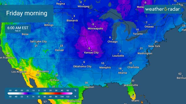
Sub-freezing temperatures down to the Gulf Coast.

While our winter storm is moving out, the deep freeze continues into Friday. We're tracking sub-freezing lows all the way to the Gulf Coast on the TemperatureRadar.

Mary Mays
More on the topic
Record ocean heat halting hurricanes. Strong El Niño influence. . . Sunday, September 13, 2026
A weather map shows a calm Atlantic Ocean with no hurricanes, alongside a picture of the sea.
Sunday, September 13, 2026

Strong El Niño influence

Record ocean heat halting hurricanes
Hurricane Polo remains dangerous. Active Pacific. . . Thursday, September 24, 2026
Thursday, September 24, 2026

Active Pacific

Hurricane Polo remains dangerous
10 facts about fog. Low clouds. . . Sunday, September 27, 2026
Fog impacting the Appalachian Mountains.
Sunday, September 27, 2026

Low clouds

10 facts about fog
All weather news
This might also interest you
Santa Ana winds start up. Southern California. . . Thursday, October 15, 2026
Thursday, October 15, 2026

Southern California

Santa Ana winds start up
Isaias post-landfall impacts. Southeast soaker. . . Saturday, October 10, 2026
Southeast impacts of Isaias
Saturday, October 10, 2026

Southeast soaker

Isaias post-landfall impacts
45-degree temperature spread. Summer, fall on one map. . . Monday, October 12, 2026
Monday, October 12, 2026

Summer, fall on one map

45-degree temperature spread
All articles
Weather & Radar

Weather & Radar is also available on

Google Play StoreApp Store

Company

Contact us Privacy policy Legal info Accessibility statement

Services

Uploader

Socials

instagramfacebookthreadslinkList