Home
Weather New York
WeatherRadar
RainRadar
TemperatureRadar
WindRadar
LightningRadar
Weather News
Editor's Pick
Discover the app
Weather widget
Contact us
Apps
Career
    Home / Editor's Pick /

    South Florida's storms - Waterspouts possible, what are they?

07:00 PM
August 9, 2026

They can be dangerous
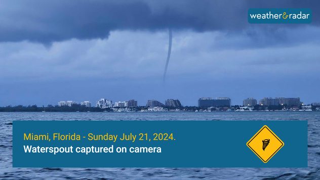
Waterspouts possible, what are they?

Waterspout seen from a boat near the Miami shore.

Waterspouts are quite a view! They can happen in any body of water, and although they are similar to tornadoes, they form differently.

Waterspouts form because of the large difference in temperatures. When water temperatures are warm, the warm air rises rapidly, towering from the cumulus clouds, and there is a rotating motion over the surface of the water. Surface winds can reach 50 mph and can produce a spray at the base of the waterspout. If a waterspout moves over land, it is called a tornado. They can cause property damage, and they are usually short-lived.

MAY 2023-Waterspout amazes FL onlookersread more

Waterspouts look like thin ropes. These water twisters can develop from thunderstorms and when there is fair weather. Waterspouts that develop from storms form downward from the base of a cloud. Fair-weather waterspouts develop on the surface of the water and work their way upward; they form in light wind conditions and hardly move.

Make sure to stay informed about the latest weather conditions and track storms using our WeatherRadar.

Irene Sans
More on the topic
Super Typhoon Bavi threatens Taiwan. 155 mph winds. . Weather Videos. Wednesday, July 8, 2026
The image shows an intense tropical cyclone over the western Pacific, east of Taiwan and the Philippines. The centre of the system is depicted as a light purple and white vortex with a clearly visible eye, surrounded by a ring of red and orange areas indicating the strongest wind speeds. A white arrow marks the typhoon’s predicted track towards the north-west, in the direction of Taiwan. To the west of the storm lie the Philippines, with the cities of Manila and Cebu; to the north of these lies Taiwan, with Taipei. Further west, the Chinese coast, including Hong Kong, and parts of Vietnam can be seen. The coloured wind map shows predominantly green areas outside the storm’s core, indicating significantly weaker winds. White streamlines illustrate the typhoon’s anti-clockwise circulation in the Northern Hemisphere. The highest wind speeds are concentrated around the eye of the cyclone.
Weather VideosWednesday, July 8, 2026

155 mph winds

Super Typhoon Bavi threatens Taiwan
What are weather fronts?. Weather explained. . . Sunday, August 23, 2026
Image of a temperature radar showing a clear distinction between a warm and cold air mass separated by a cold front.
Sunday, August 23, 2026

Weather explained

What are weather fronts?
All about nocturnal severe weather. Risks & preparedness. . . Saturday, August 22, 2026
Saturday, August 22, 2026

Risks & preparedness

All about nocturnal severe weather
All weather news
This might also interest you
Wildfire explodes to 15k+ acres. Air quality concerns. . . Monday, August 24, 2026
Monday, August 24, 2026

Air quality concerns

Wildfire explodes to 15k+ acres
Gravity wave clouds explained. The ideal conditions. . . Saturday, August 22, 2026
Saturday, August 22, 2026

The ideal conditions

Gravity wave clouds explained
Dust Bowl period record could fall. North Texas. . . Tuesday, August 25, 2026
Tuesday, August 25, 2026

North Texas

Dust Bowl period record could fall
All articles
Weather & Radar

Weather & Radar is also available on

Google Play StoreApp Store

Company

Contact us Privacy policy Legal info Accessibility statement

Services

Uploader

Socials

instagramfacebookthreadslinkList