Home
Weather New York
WeatherRadar
RainRadar
TemperatureRadar
WindRadar
LightningRadar
Weather News
Editor's Pick
Discover the app
Weather widget
Contact us
Apps
Career
Home / Weather News /

Southeast storms continue, active West

08:00 AM
May 12, 2025

Breakfast Brief
Southeast storms continue, active West

A slow-moving low will continue to bring showers and storms to the Southeast, while active weather enters the picture for the West Coast. The Breakfast Brief is published Monday through Friday at 5:00 a.m. Eastern Time.

After soggy conditions over the weekend, the Southeast will continue to see rain and storms as a slow-moving low continues to meander. Flash flooding is a concern from north Florida to the Carolinas, with cities like Jacksonville, Fla., Savannah, Ga., and Charlotte, N.C., at risk.

The WeatherRadar shows storms continuing across the Southeast.

The WeatherRadar also shows action on the West Coast. After relatively tranquil conditions last week, rain and mountain snow have returned. Cities like Seattle, Portland, Ore., and San Francisco will be in for messy commutes this morning as moisture surges in from the Pacific.

Rain-cooled air will also keep highs below average for the West Coast. However, record heat is in play for the northern Plains and Upper Midwest, where temperatures will run up to 25 degrees above average. Cities like Bismarck, N.D., and Rapid City, S.D., may see record highs today as temperatures surge into the 90s!

While the central part of the country will experience above-average temperatures, the Southeast remains cooler than average due to rain and thunderstorms.

News we're covering today
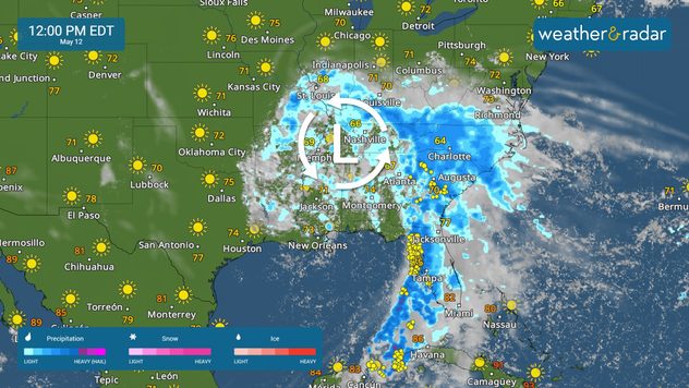
  • Flood threat across the Southeast
  • Record heat across the northern Plains and Upper Midwest

Things you may have missed

Great Lakes spring chillread more

App news

When severe weather is in your forecast, you can be prepared. Follow along with these tools to stay weather-aware.

Mary Mays
More on the topic
fog
Sunday, February 22, 2026

Safety tips: fog

Driving during foggy conditions
Image of a temperature radar showing a clear distinction between a warm and cold air mass separated by a cold front.
Saturday, February 28, 2026

Weather explained

What are weather fronts?
Thursday, February 12, 2026

Risks & preparedness

All about nocturnal severe weather
All weather news
This might also interest you
Thursday, February 26, 2026

Strongest for Jamaica

Melissa tied for strongest Atlantic hurricane
Monday, March 2, 2026

Snow, rain & ice

Wintry mix for Mid-Atlantic, Northeast
Wednesday, March 4, 2026

Beginning Friday

Flood risk from Texas to Mississippi Valley
All articles
Weather & Radar
US
Clima & Radar Brasil
Hava durumu & Radar Türkiye
Időjárás és Radar Magyarország
Καιρός & Ραντάρ Ελλάδα
Météo & Radar Belgique (Français)
Météo & Radar France
Meteo & Radar Italia
Meteo & Radar România
Météo & Radar Suisse (Français)
Meteo & Radars Latvija
OrasOnline Lietuva
Počasí & Radar Czechia
Počasie & Radar Slovensko
Pogoda & Radar Polska
Погода & Радар Україна (українська)
Tempo & Radar Portugal
Tiempo & Radar Argentina
Tiempo & Radar España
Vejr & Radar Danmark
Vreme & Radar Slovenija
Vreme & Radar Srbija
Vrijeme & Radar Bosna
Vrijeme & Radar Crna Gora
Vrijeme & Radar Hrvatska
Време & Радар България
Времето & Радар Macedonia
Weather & Radar India (English)
Weather & Radar Ireland
Weather & Radar United Kingdom
Weather & Radar USA (Español)
Weer & Radar België (Nederlands)
Weer & Radar Nederland

Weather & Radar is also available on

Google Play StoreApp Store

Company

Contact us Privacy policy Legal info Accessibility statement

Services

Uploader

Socials

instagramfacebookthreadslinkList