Home
Weather New York
WeatherRadar
RainRadar
TemperatureRadar
WindRadar
LightningRadar
Weather News
Editor's Pick
Discover the app
Weather widget
Contact us
Apps
Career
    Home / Weather News /

    Southeast U.S. - Multi-day rain event ends soon

05:26 PM
July 24, 2026

Southeast U.S.
Multi-day rain event ends soon

Heavy rains have been falling across the Carolinas and Southeast since early in the week, but relief is not far. Flooding impacts are expected through Saturday.

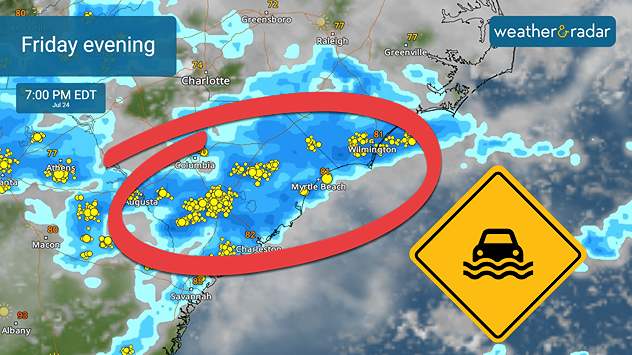
Although a flash-flood risk is active from the mid-Mississippi Valley through the Carolinas, a focus area includes places like Charleston, Columbia and Myrtle Beach, S.C., as well as Wilmington, N.C. Rain rates of 2 to 3 inches per hour are expected on Friday, and the WeatherRadar shows plenty of activity lasting through Saturday.

Flash flooding is possible Friday evening along the Southeast Coast into central South Carolina.

Heavy rain alerts are active for the focus area of the Southeast Coast. Make sure you're receiving the most up-to-date notifications on your Weather & Radar app.

Activate your weather alertsread more
Becca Parker
More on the topic
Europe: Warmest June on record. Warm waters too. . . Friday, July 10, 2026
The record-breaking heatwave in June has made climate history in Western Europe.
Friday, July 10, 2026

Warm waters too

Europe: Warmest June on record
Super Typhoon Bavi threatens Taiwan. 155 mph winds. . Weather Videos. Wednesday, July 8, 2026
The image shows an intense tropical cyclone over the western Pacific, east of Taiwan and the Philippines. The centre of the system is depicted as a light purple and white vortex with a clearly visible eye, surrounded by a ring of red and orange areas indicating the strongest wind speeds. A white arrow marks the typhoon’s predicted track towards the north-west, in the direction of Taiwan. To the west of the storm lie the Philippines, with the cities of Manila and Cebu; to the north of these lies Taiwan, with Taipei. Further west, the Chinese coast, including Hong Kong, and parts of Vietnam can be seen. The coloured wind map shows predominantly green areas outside the storm’s core, indicating significantly weaker winds. White streamlines illustrate the typhoon’s anti-clockwise circulation in the Northern Hemisphere. The highest wind speeds are concentrated around the eye of the cyclone.
Weather VideosWednesday, July 8, 2026

155 mph winds

Super Typhoon Bavi threatens Taiwan
Longest day of the year is here. Summer solstice. . . Sunday, June 21, 2026
Sunday, June 21, 2026

Summer solstice

Longest day of the year is here
All weather news
This might also interest you
Hurricane Lala passes south of the Big Island. Flooding, wind in Hawaii. . . Sunday, August 16, 2026
Lala will continue to downgrade and pass south of the rest of the Hawaiian islands.
Sunday, August 16, 2026

Flooding, wind in Hawaii

Hurricane Lala passes south of the Big Island
Gravity wave spotted on WeatherRadar. Moving into TN. . . Monday, August 17, 2026
Monday, August 17, 2026

Moving into TN

Gravity wave spotted on WeatherRadar
6 riskiest places to live: hurricane edition. Do you live there?. . . Sunday, August 16, 2026
Hurricane Irma covers the entiret of Florida with Hurricane Maria coming up behind it.
Sunday, August 16, 2026

Do you live there?

6 riskiest places to live: hurricane edition
All articles
Weather & Radar

Weather & Radar is also available on

Google Play StoreApp Store

Company

Contact us Privacy policy Legal info Accessibility statement

Services

Uploader

Socials

instagramfacebookthreadslinkList