Home
Weather New York
WeatherRadar
RainRadar
TemperatureRadar
WindRadar
LightningRadar
Weather News
Editor's Pick
Discover the app
Weather widget
Contact us
Apps
Career
    Home / Weather News /

    Southern California - 100 miles, 30-degree difference

06:22 PM
July 9, 2026

Southern California
100 miles, 30-degree difference

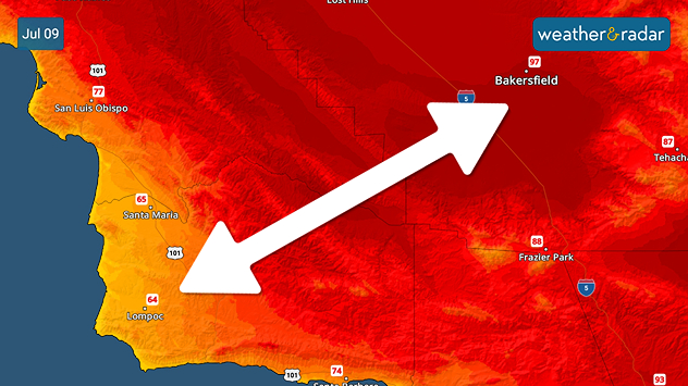
A more than 30-degree temperature difference is apparent in California between the southern Central Valley and the coast.

Bakersfield, California, is less than 100 miles from the coastline, but temperatures are 30 degrees warmer. At this rate, the temperature changes by more than a quarter of a degree per mile.

The TemperatureRadar shows a sharp gradient between the coast and the Central Valley in California. Topography and wind direction both play a part.

First, along the coast, winds are blowing off the cool Pacific waters. Currently, water temperatures are in the chilly 50s due to the water current's circulation bringing cold water down from the north. These winds keep California's coast much cooler than further inland.

Secondly, the Central Valley's topography is exactly that - a valley. This area tends to be much warmer, especially during times of high pressure, due to dense sinking air heating up and dispersing throughout the valley.

A heatwave is building in the West. While temperatures will increase all over California, some will still be comfortable thanks to the coastal winds and higher elevation.

Becca Parker
More on the topic
Super Typhoon Bavi threatens Taiwan. 155 mph winds. . Weather Videos. Wednesday, July 8, 2026
The image shows an intense tropical cyclone over the western Pacific, east of Taiwan and the Philippines. The centre of the system is depicted as a light purple and white vortex with a clearly visible eye, surrounded by a ring of red and orange areas indicating the strongest wind speeds. A white arrow marks the typhoon’s predicted track towards the north-west, in the direction of Taiwan. To the west of the storm lie the Philippines, with the cities of Manila and Cebu; to the north of these lies Taiwan, with Taipei. Further west, the Chinese coast, including Hong Kong, and parts of Vietnam can be seen. The coloured wind map shows predominantly green areas outside the storm’s core, indicating significantly weaker winds. White streamlines illustrate the typhoon’s anti-clockwise circulation in the Northern Hemisphere. The highest wind speeds are concentrated around the eye of the cyclone.
Weather VideosWednesday, July 8, 2026

155 mph winds

Super Typhoon Bavi threatens Taiwan
Record-breaking heatwave in Europe. Hotter than most of U.S.. . . Thursday, June 25, 2026
Thursday, June 25, 2026

Hotter than most of U.S.

Record-breaking heatwave in Europe
El Niño is gaining momentum. Temperature records?. . . Thursday, May 7, 2026
The image shows the central Pacific in a computer model. A striking feature is the ocean coloured red, which indicates very warm seawater.
Thursday, May 7, 2026

Temperature records?

El Niño is gaining momentum
All weather news
This might also interest you
Slow-moving storms and heavy rain. What to look for. . . Monday, July 6, 2026
Monday, July 6, 2026

What to look for

Slow-moving storms and heavy rain
Watch the heatwave build. Record-breaking heat. . . Monday, June 29, 2026
Monday, June 29, 2026

Record-breaking heat

Watch the heatwave build
Tough sleeping temperatures too. Stifling hot night & day. . . Thursday, July 2, 2026
Friday's temperatures
Thursday, July 2, 2026

Stifling hot night & day

Tough sleeping temperatures too
All articles
Weather & Radar

Weather & Radar is also available on

Google Play StoreApp Store

Company

Contact us Privacy policy Legal info Accessibility statement

Services

Uploader

Socials

instagramfacebookthreadslinkList