Home
Weather New York
WeatherRadar
RainRadar
TemperatureRadar
WindRadar
LightningRadar
Weather News
Editor's Pick
Discover the app
Weather widget
Contact us
Apps
Career
    Home / Editor's Pick /

    Southern Plains: lingering rain increases flood risk

03:26 PM
May 30, 2024

Southern Plains
Lingering rain increases flood risk

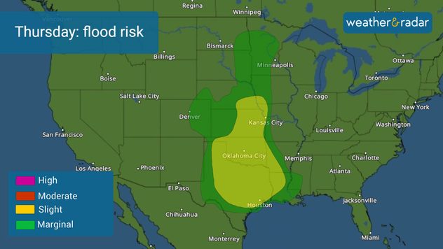
Flood risk on Thursday

The flood risk continues for Texas through Oklahoma to end the work-week as the showers and thunderstorms stay put.

The week ends with the risk of flooding for the same general region as another system slowly travels over Texas, pushing some fronts that will increase the instability and create several rounds of showers and thunderstorms through Saturday.

Rainfall totals across at-risk areas will range between 2 and 4 inches with some isolated spots that could receive up to 6 inches through Saturday. This is on top of all the rains that have recently fallen across these same areas. The ground is already well saturated, flooding could develop quickly. Please remember to turn around, don't drown.

Stormy Thursday for Texas, N.M.read more

The risk for showers and thunderstorms will stick through at least through Sunday, with fewer chances to start next week across North Texas and Oklahoma. If you have plans outdoors this weekend, make sure you have a plan to bring it indoors and check on the forecast throughout the next few days.

Irene Sans
More on the topic
Super Typhoon Near the Philippines. Gusts up to 155. . . Tuesday, June 23, 2026
Tuesday, June 23, 2026

Gusts up to 155

Super Typhoon Near the Philippines
Rip currents & safety tips. As more head to the coast. . . Sunday, July 5, 2026
rip current
Sunday, July 5, 2026

As more head to the coast

Rip currents & safety tips
Super Typhoon Bavi threatens Taiwan. 155 mph winds. . Weather Videos. Wednesday, July 8, 2026
The image shows an intense tropical cyclone over the western Pacific, east of Taiwan and the Philippines. The centre of the system is depicted as a light purple and white vortex with a clearly visible eye, surrounded by a ring of red and orange areas indicating the strongest wind speeds. A white arrow marks the typhoon’s predicted track towards the north-west, in the direction of Taiwan. To the west of the storm lie the Philippines, with the cities of Manila and Cebu; to the north of these lies Taiwan, with Taipei. Further west, the Chinese coast, including Hong Kong, and parts of Vietnam can be seen. The coloured wind map shows predominantly green areas outside the storm’s core, indicating significantly weaker winds. White streamlines illustrate the typhoon’s anti-clockwise circulation in the Northern Hemisphere. The highest wind speeds are concentrated around the eye of the cyclone.
Weather VideosWednesday, July 8, 2026

155 mph winds

Super Typhoon Bavi threatens Taiwan
All weather news
This might also interest you
Dangerous air quality continues. Canada wildfires smoke. . . Friday, July 17, 2026
Smoky Philadelphia
Friday, July 17, 2026

Canada wildfires smoke

Dangerous air quality continues
Northern New England storms. Rare severe threat. . . Tuesday, July 14, 2026
Tuesday, July 14, 2026

Rare severe threat

Northern New England storms
When severe storms strike.... You can be ready. . . Saturday, July 18, 2026
Saturday, July 18, 2026

You can be ready

When severe storms strike...
All articles
Weather & Radar

Weather & Radar is also available on

Google Play StoreApp Store

Company

Contact us Privacy policy Legal info Accessibility statement

Services

Uploader

Socials

instagramfacebookthreadslinkList