Home
Weather New York
WeatherRadar
RainRadar
TemperatureRadar
WindRadar
LightningRadar
Weather News
Editor's Pick
Discover the app
Weather widget
Contact us
Apps
Career
    Home / Weather News /

    Staying safe this summer: Lightning season in full bloom

08:00 PM
July 6, 2026

Staying safe this summer
Lightning season in full bloom

Lightning Season
Summer is lightning season across the U.S.

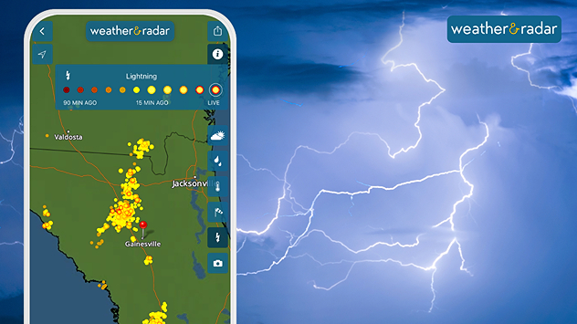
Summer is lightning season, with thunderstorms popping up across many places during the afternoon and evening. Be safe and stay weather aware.

Sadly, a family was struck by lightning last Friday on Fort Myers Beach, Fla., killing one and injuring three others. There have been three deaths attributed to lightning this year in the U.S., two of them in Florida.

Florida is the U.S.'s Lightning Capital

Although nicknamed the Sunshine State, Florida is also the lightning capital of the U.S. Each year, more than a 1 million lightning flashes are recorded by sensors with nearly 7 of 10 of them occurring during the summer months.  

Summer outdoor activities should always be planned around weather dangers. If thunderstorms are in the forecast, someone should always monitor Weather & Radar often to track storm developments. The WeatherRadar and LightningRadar are great options for this. Be prepared to act quickly when thunderstorms appear by heading to a sturdy structure or at least to a car.

Another way to not be caught off guard, turn on the Weather Alerts directly in the application.

Slow-moving storms bring heavy rain tooread more
James West
More on the topic
Europe: Warmest June on record. Warm waters too. . . Friday, July 10, 2026
The record-breaking heatwave in June has made climate history in Western Europe.
Friday, July 10, 2026

Warm waters too

Europe: Warmest June on record
Rip currents & safety tips. As more head to the coast. . . Sunday, July 5, 2026
rip current
Sunday, July 5, 2026

As more head to the coast

Rip currents & safety tips
Super Typhoon Bavi threatens Taiwan. 155 mph winds. . Weather Videos. Wednesday, July 8, 2026
The image shows an intense tropical cyclone over the western Pacific, east of Taiwan and the Philippines. The centre of the system is depicted as a light purple and white vortex with a clearly visible eye, surrounded by a ring of red and orange areas indicating the strongest wind speeds. A white arrow marks the typhoon’s predicted track towards the north-west, in the direction of Taiwan. To the west of the storm lie the Philippines, with the cities of Manila and Cebu; to the north of these lies Taiwan, with Taipei. Further west, the Chinese coast, including Hong Kong, and parts of Vietnam can be seen. The coloured wind map shows predominantly green areas outside the storm’s core, indicating significantly weaker winds. White streamlines illustrate the typhoon’s anti-clockwise circulation in the Northern Hemisphere. The highest wind speeds are concentrated around the eye of the cyclone.
Weather VideosWednesday, July 8, 2026

155 mph winds

Super Typhoon Bavi threatens Taiwan
All weather news
This might also interest you
Hotter in Detroit than Miami. Heatwave begins. . . Tuesday, June 30, 2026
Tuesday, June 30, 2026

Heatwave begins

Hotter in Detroit than Miami
Slow-moving storms and heavy rain. What to look for. . . Monday, July 6, 2026
Monday, July 6, 2026

What to look for

Slow-moving storms and heavy rain
Saharan dust to reach Florida. Dry period expected. . . Tuesday, July 7, 2026
Saharan dust seen on the satllite image (right) moving westward toward Florida. Air quality impacts are expected.
Tuesday, July 7, 2026

Dry period expected

Saharan dust to reach Florida
All articles
Weather & Radar

Weather & Radar is also available on

Google Play StoreApp Store

Company

Contact us Privacy policy Legal info Accessibility statement

Services

Uploader

Socials

instagramfacebookthreadslinkList