Home
Weather New York
WeatherRadar
RainRadar
TemperatureRadar
WindRadar
LightningRadar
Weather News
Editor's Pick
Discover the app
Weather widget
Contact us
Apps
Career
    Home / Weather News /

    Stifling hot night & day - Tough sleeping temperatures too

03:24 PM
July 2, 2026

Stifling hot night & day
Tough sleeping temperatures too

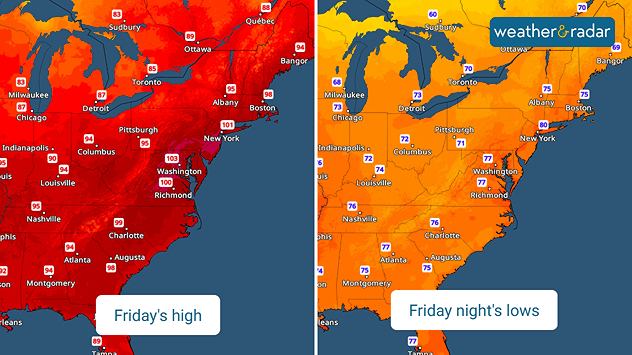
Friday's highs versus lows
Hot days and nights ahead for the East Coast

A record-breaking heat wave continues across the Midwest, South and East Coast into the holiday weekend. No break from the heat as nighttime temperatures barely drop.

Weather & Radar has been warning the U.S. east of the Rockies since the beginning of the week about a major heat wave spreading across the southern and eastern U.S. The TemperatureRadar shows highs for the next several days will be in the upper 90s, with record-breaking 100-105 degree highs today and Friday along the I-95 corridor from Washington northward into Philadelphia and the New York City metro.

Latest Heat wave storiesread more

If the hot days weren't enough, there won't be any relief at night either. Building humidity, the heat building up during the hot and sunny days and the short nights make it hard for temperatures to drop at night.

Many of the same places that will set daytime high temperature records could see nighttime lows only drop into the low 80s, setting new records for warmest nighttime lows.

New York

Tu
72
95
We
79
100
Th
81
96
Fr
79
92
Sa
74
77
Su
73
86
Mo
72
87
Tu
74
88
We
75
87
Th
75
87
Fr
75
89
Sa
77
91
Su
75
90
Mo
75
89
Max (°F)
Min (°F)
moreless

The WeatherRadar won't offer much hope of stormy relief for the boiling East Coast either. A few pop-up thunderstorms are possible across the South, Midwest and Great Lakes the next couple afternoons. The biggest storm chances will occur Saturday and Sunday evenings before a return to more seasonable temperatures next week.

James West
More on the topic
How does fog form?. Multiple ways. . . Saturday, July 11, 2026
Saturday, July 11, 2026

Multiple ways

How does fog form?
Super Typhoon Near the Philippines. Gusts up to 155. . . Tuesday, June 23, 2026
Tuesday, June 23, 2026

Gusts up to 155

Super Typhoon Near the Philippines
Super Typhoon Bavi threatens Taiwan. 155 mph winds. . Weather Videos. Wednesday, July 8, 2026
The image shows an intense tropical cyclone over the western Pacific, east of Taiwan and the Philippines. The centre of the system is depicted as a light purple and white vortex with a clearly visible eye, surrounded by a ring of red and orange areas indicating the strongest wind speeds. A white arrow marks the typhoon’s predicted track towards the north-west, in the direction of Taiwan. To the west of the storm lie the Philippines, with the cities of Manila and Cebu; to the north of these lies Taiwan, with Taipei. Further west, the Chinese coast, including Hong Kong, and parts of Vietnam can be seen. The coloured wind map shows predominantly green areas outside the storm’s core, indicating significantly weaker winds. White streamlines illustrate the typhoon’s anti-clockwise circulation in the Northern Hemisphere. The highest wind speeds are concentrated around the eye of the cyclone.
Weather VideosWednesday, July 8, 2026

155 mph winds

Super Typhoon Bavi threatens Taiwan
All weather news
This might also interest you
Follow the clouds. High-pressure ridge. . . Monday, July 13, 2026
Monday, July 13, 2026

High-pressure ridge

Follow the clouds
Fireworks and Air Quality. Smoke and pollution. . . Saturday, July 4, 2026
Saturday, July 4, 2026

Smoke and pollution

Fireworks and Air Quality
Lightning season in full bloom. Staying safe this summer. . . Monday, July 6, 2026
Monday, July 6, 2026

Staying safe this summer

Lightning season in full bloom
All articles
Weather & Radar

Weather & Radar is also available on

Google Play StoreApp Store

Company

Contact us Privacy policy Legal info Accessibility statement

Services

Uploader

Socials

instagramfacebookthreadslinkList