Home
Weather New York
WeatherRadar
RainRadar
TemperatureRadar
WindRadar
LightningRadar
Weather News
Editor's Pick
Discover the app
Weather widget
Contact us
Apps
Career
    Home / Editor's Pick /

    Strong cold front moves east, drenched West

10:00 AM
November 19, 2024

Breakfast Brief
Strong cold front moves east, drenched West

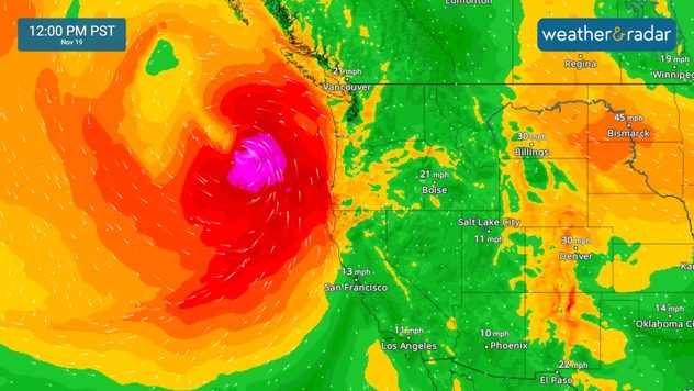
Active weather courtesy of a cold front pushes east on Tuesday into the Mississippi River Valley, while intense precipitation of all types batter the Pacific Northwest. The Breakfast Brief is published every Monday through Friday at 5 a.m. ET

A potent cold front will enter the Southeast on Tuesday, increasing the chance for widespread showers, which can produce flash floods and even the chance for some isolated severe storms to develop across eastern Mississippi, Alabama, and into the Florida Panhandle. In these regions, storms that do turn severe may develop isolated tornadoes. The highest threat for these will be along the immediate coast, south of I-10.

Tuesday will be an active day across parts of the Deep South into the Southeast, with a strong cold front and Sara's remnants producing plenty of showers.

A stronger atmospheric river enters the Pacific Northwest. This channel of deep moisture will increase the flood threat in the coming days and likely produce flash floods across northern California and southwestern Oregon. Plan carefully; these rains and heavy mountain snow could produce landslides. Our WindRadar shows that the winds will also increase, especially from Wednesday on, producing power outages.

Keep your app alerts on and have at least three ways to receive a weather warning.

1/2

November 19, 1930

A rare, estimated F4 tornado struck the town of Bethany, Okla. Between 9:30 a.m. and 9:58 a.m. CST, it moved north-northeast from 3 miles west of the Oklahoma City limits, and hit the eastern part of Bethany. About 110 homes and 700 other buildings, or about a fourth of the town, were damaged or destroyed. 23 people were killed and 150 injured. Damage estimates were listed at $500,000. 

Tropical update:

Is this the beginning of the end of hurricane season? It could be! No areas are currently being monitored over the Atlantic Basin.

News we are covering today:

  • Severe weather & flash flood risk for the Southeast
  • Wind & cold plunge for the Central Plains
  • Atmospheric river enters the west

Did you miss these?

Update: Cold = potholesread more
A town that uses mirrors for sunlightread more

App news & updates:

Thanksgiving is around the corner! Tune in to our YouTube page on November 25, 26 and 27, 2024 for live travel forecasts.

Irene Sans
More on the topic
Saturday, April 18, 2026

Risks & preparedness

All about nocturnal severe weather
EF-2 tornado pictured in Colorado
Saturday, April 18, 2026

World of Twisters

Tornado myths answered
The Lyrids peak tonight.
Tuesday, April 21, 2026

Make a wish!

Lyrid meteor shower reaches its peak
All weather news
This might also interest you
Severe weather is expected to develop across the central Plains and Midwest this afternoon and evening, with the most significant risk being centered across the central Plains.
Monday, May 18, 2026

Strong tornadoes possible

Severe outbreak in the Plains
Indianapolis 500
Sunday, May 24, 2026

Race delays possible

Indy 500 rain chances
A heatwave will challenge record highs across the Eastern U.S. today and tomorrow.
Tuesday, May 19, 2026

Today and tomorrow

Record heat for the East
All articles
Weather & Radar

Weather & Radar is also available on

Google Play StoreApp Store

Company

Contact us Privacy policy Legal info Accessibility statement

Services

Uploader

Socials

instagramfacebookthreadslinkList