Home
Weather New York
WeatherRadar
RainRadar
TemperatureRadar
WindRadar
LightningRadar
Weather News
Editor's Pick
Discover the app
Weather widget
Contact us
Apps
Career
    Home / Editor's Pick /

    Strong earthquake off Russia's east coast – tsunami warning in the Pacific

11:30 AM
July 30, 2025

Pacific tsunami warning
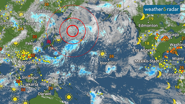
Strong quake off Russia's east coast

The epicentre of the earthquake was located off the coast of Kamchatka at a depth of around 12.9 miles.

A severe earthquake measuring 8.8 on the Richter scale struck off the Russian peninsula of Kamchatka last night.

It is the strongest earthquake since Fukushima in 2011. Tsunami warnings have been issued around the Pacific.

Privacy policy
Images and videos of the tsunami in Kamchatka are already circulating on social media.

The first tsunami waves, up to 9 feet high, reached the coasts of Kamchatka and the Japanese Kuril Islands yesterday. Tsunami warnings were issued for many other regions from Hawaii to Alaska and the West Coast following the earthquake.

Tsunami waves reached Hawaii overnight, with the highest being 5.7 feet on Maui. Authorities will be examining the beaches later today. Hawaii and the West Coast remain under Tsunami Advisories for the time being.

According to initial reports, there were no injuries, which is likely due to the remote peninsula's low population density in the Pacific. Additionally, coastal residents in Japan were advised to seek safety.

The tremors were the sixth strongest since records began. Further strong aftershocks are expected during the course of the day.

Mary Mays
More on the topic
Meteorological summer is here!. Bye, spring!. . . Monday, June 1, 2026
Monday, June 1, 2026

Bye, spring!

Meteorological summer is here!
Super Typhoon Bavi threatens Taiwan. 155 mph winds. . Weather Videos. Wednesday, July 8, 2026
The image shows an intense tropical cyclone over the western Pacific, east of Taiwan and the Philippines. The centre of the system is depicted as a light purple and white vortex with a clearly visible eye, surrounded by a ring of red and orange areas indicating the strongest wind speeds. A white arrow marks the typhoon’s predicted track towards the north-west, in the direction of Taiwan. To the west of the storm lie the Philippines, with the cities of Manila and Cebu; to the north of these lies Taiwan, with Taipei. Further west, the Chinese coast, including Hong Kong, and parts of Vietnam can be seen. The coloured wind map shows predominantly green areas outside the storm’s core, indicating significantly weaker winds. White streamlines illustrate the typhoon’s anti-clockwise circulation in the Northern Hemisphere. The highest wind speeds are concentrated around the eye of the cyclone.
Weather VideosWednesday, July 8, 2026

155 mph winds

Super Typhoon Bavi threatens Taiwan
High pressure & extreme heat. Why & how does it work?. . . Sunday, July 12, 2026
Sunday, July 12, 2026

Why & how does it work?

High pressure & extreme heat
All weather news
This might also interest you
Temps 15-degrees below average. Big cold front. . . Wednesday, July 22, 2026
Wednesday, July 22, 2026

Big cold front

Temps 15-degrees below average
When severe storms strike.... You can be ready. . . Sunday, July 26, 2026
Sunday, July 26, 2026

You can be ready

When severe storms strike...
Lopsided Bertha moves west. Who sees the impacts. . . Thursday, July 23, 2026
Thursday, July 23, 2026

Who sees the impacts

Lopsided Bertha moves west
All articles
Weather & Radar

Weather & Radar is also available on

Google Play StoreApp Store

Company

Contact us Privacy policy Legal info Accessibility statement

Services

Uploader

Socials

instagramfacebookthreadslinkList