Home
Weather New York
WeatherRadar
RainRadar
TemperatureRadar
WindRadar
LightningRadar
Weather News
Editor's Pick
Discover the app
Weather widget
Contact us
Apps
Career
    Home / Editor's Pick /

    Sugarcane burns: Parts of South Florida hazy & at risk

06:45 PM
May 3, 2023

Sugarcane burns
Parts of South Florida hazy & at risk

sugarcane burns

Prescribed sugarcane burns are producing strong smoky smells and lots of haze across South Florida for the last few days.The west winds persist on Wednesday and start to shift from the north on Thursday.

Privacy policy

West Broward County in South Florida has been under a haze for the last two days. Smoke was the common strong smell over cities such as Sunrise, Weston, Plantation, Coral Springs, and Parkland. Sugarcane-prescribed burns are the ones to blame for the itch in some people’s eyes.

Florida’s main sugar-producing region is known as the Glades, located south of Lake Okeechobee.
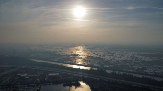
Sugarcane fires are happening over areas around the south and southeastern periphery of Lake Okeechobee. At first glance, the acreage of each fire is not impressive, as compared to other big fires, but since there are more than a dozen of them, big smoke quickly builds. Acreage varies between 30 to 76 acres for each fire.

This look facing west toward the Everglades. Sugarcane fires are located just south of Lake Okeechobee. Drone pictures by Alejandro R.
Drone picture shows the hazy skies as the smoke arrives to parts of west Broward causing smoky smells and lots of itch eyes.
1/4

Sugarcane fires are usually done between the months of October to May. This season’s weather has affected crops and weather events could extend the burn season. Sugarcane burns because the dried leaves accumulate around the bases of the cane and if they are not cleared properly fires can ignite easily and become uncontrollable if weather conditions are just right. Also, leftover dried leaves, if left behind, could slow down the next season’s growth and put a damp on the local economy, workers' livelihood, and sugar production itself.

Sugarcane in the U.S. is usually planted in late summer and overwinters. It takes about 7 to 8 months for them to grow, so they are usually grown by spring to early fall. It can take them a while to mature, but they grow fast, especially in hot weather.

These burns do produce very large smoke plumes and have been the cause of many debates. Residents around the area of usual burns often complain of the health risk these burns cause. It has been found that sugarcane burning can produce large quantities of cancer-causing pollutants, this is beside the common risks of breathing problems, like asthma attacks, sinuses, etc. These burns should be monitored closely by authorities and are often done when the winds are favorable to not affect large residential areas. Florida sticks out like a sore thumb, and winds are often variable, especially during the spring when we still have cold fronts pushing through, putting a large population at risk. The last few days we've had constant west winds, which swang the smoke toward highly populated suburbs of west Broward County.

Looking at the latest model from the National Center for Atmospheric Research (NCAR)’ Atmospheric Chemistry Observations and Modeling (ACOM) shows that Carbon Dioxide levels coming from these fires are at about 30 ppb. Although this is not in an unsafe range, if one of exposed to this level for longer than 6-7 hours, then one could start feeling symptoms and health could be impacted. If you already suffer from respiratory issues, you could start feeling symptoms sooner.

Irene Sans
More on the topic
Meteorological summer is here!. Bye, spring!. . . Monday, June 1, 2026
Monday, June 1, 2026

Bye, spring!

Meteorological summer is here!
Super Typhoon Bavi threatens Taiwan. 155 mph winds. . Weather Videos. Wednesday, July 8, 2026
The image shows an intense tropical cyclone over the western Pacific, east of Taiwan and the Philippines. The centre of the system is depicted as a light purple and white vortex with a clearly visible eye, surrounded by a ring of red and orange areas indicating the strongest wind speeds. A white arrow marks the typhoon’s predicted track towards the north-west, in the direction of Taiwan. To the west of the storm lie the Philippines, with the cities of Manila and Cebu; to the north of these lies Taiwan, with Taipei. Further west, the Chinese coast, including Hong Kong, and parts of Vietnam can be seen. The coloured wind map shows predominantly green areas outside the storm’s core, indicating significantly weaker winds. White streamlines illustrate the typhoon’s anti-clockwise circulation in the Northern Hemisphere. The highest wind speeds are concentrated around the eye of the cyclone.
Weather VideosWednesday, July 8, 2026

155 mph winds

Super Typhoon Bavi threatens Taiwan
Super Typhoon Near the Philippines. Gusts up to 155. . . Tuesday, June 23, 2026
Tuesday, June 23, 2026

Gusts up to 155

Super Typhoon Near the Philippines
All weather news
This might also interest you
Dry vegetation, low humidity and winds. The perfect fire recipe. . . Sunday, July 26, 2026
Sunday, July 26, 2026

The perfect fire recipe

Dry vegetation, low humidity and winds
Temps 15-degrees below average. Big cold front. . . Wednesday, July 22, 2026
Wednesday, July 22, 2026

Big cold front

Temps 15-degrees below average
When severe storms strike.... You can be ready. . . Sunday, July 26, 2026
Sunday, July 26, 2026

You can be ready

When severe storms strike...
All articles
Weather & Radar

Weather & Radar is also available on

Google Play StoreApp Store

Company

Contact us Privacy policy Legal info Accessibility statement

Services

Uploader

Socials

instagramfacebookthreadslinkList