Home
Weather New York
WeatherRadar
RainRadar
TemperatureRadar
WindRadar
LightningRadar
Weather News
Editor's Pick
Discover the app
Weather widget
Contact us
Apps
Career
    Home / Editor's Pick /

    Super Typhoon BAVI threatens Taiwan – 1,000 litres of rain

12:59 PM
July 8, 2026

155 mph winds
Super Typhoon Bavi threatens Taiwan

The powerful typhoon Bavi in the Western Pacific is currently heading towards Taiwan. It is expected to cross the north of the island during the overnight into Saturday, impacting capital city, Taipei.

Hurricane-force winds exceeding 155 miles per hour, waves up to 30 feet high, and heavy rainfall of up to 40 inches are expected. That is an extremely large amount. As a result, there are fears of widespread flooding and landslides.

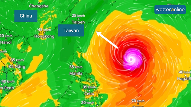
The image shows an intense tropical cyclone over the western Pacific, east of Taiwan and the Philippines. The centre of the system is depicted as a light purple and white vortex with a clearly visible eye, surrounded by a ring of red and orange areas indicating the strongest wind speeds. A white arrow marks the typhoon’s predicted track north-westwards towards Taiwan. To the west of the storm lie the Philippines, with the cities of Manila and Cebu; to the north of these lies Taiwan, with Taipei. Further west, the Chinese coast, including Hong Kong, and parts of Vietnam can be seen. The coloured wind map shows predominantly green areas outside the storm’s core, indicating significantly weaker winds. White streamlines illustrate the typhoon’s anti-clockwise circulation in the Northern Hemisphere. The highest wind speeds are concentrated around the eye of the cyclone.
WindRadar shows the typhoon, which is now moving towards Taiwan.

The typhoon has a diameter of around 620 miles, which is unusually large for a cyclone. Allowing the system to bring prolonged rainfall as it crosses the island, which also explains the high accumulation totals.

After passing over Taiwan, Bavi makes landfall on the east coast of China in a slightly weakened form. By then, both the rainfall and the gusts of wind are no longer quite as severe.

Did you know?

Super typhoons are among the strongest tropical cyclones in the world and are equivalent to a Category 5 hurricane.

Over the past few days, the storm has already hit the Mariana Islands. Wind gusts of over 185 mph were recorded there, and numerous buildings were destroyed.

One reason for the high number of powerful typhoons could be El Niño, which causes sea temperatures in the eastern Pacific to rise. During an El Niño event, the likelihood of powerful cyclones in the Pacific generally increases.

Verena Leyendecker
More on the topic
Longest day of the year is here. Summer solstice. . . Sunday, June 21, 2026
Sunday, June 21, 2026

Summer solstice

Longest day of the year is here
Rip currents & safety tips. As more head to the coast. . . Sunday, July 5, 2026
rip current
Sunday, July 5, 2026

As more head to the coast

Rip currents & safety tips
Heat wave setting records across Europe. London breaks May record. . . Tuesday, May 26, 2026
European heat wave
Tuesday, May 26, 2026

London breaks May record

Heat wave setting records across Europe
All weather news
This might also interest you
Saharan dust to reach Florida. Dry period expected. . . Tuesday, July 7, 2026
Saharan dust seen on the satllite image (right) moving westward toward Florida. Air quality impacts are expected.
Tuesday, July 7, 2026

Dry period expected

Saharan dust to reach Florida
Hotter in Detroit than Miami. Heatwave begins. . . Tuesday, June 30, 2026
Tuesday, June 30, 2026

Heatwave begins

Hotter in Detroit than Miami
Turning hot this weekend. Brutal temps across West. . . Friday, July 10, 2026
Saturday & Sunday's highs
Friday, July 10, 2026

Brutal temps across West

Turning hot this weekend
All articles
Weather & Radar

Weather & Radar is also available on

Google Play StoreApp Store

Company

Contact us Privacy policy Legal info Accessibility statement

Services

Uploader

Socials

instagramfacebookthreadslinkList