Home
Weather New York
WeatherRadar
RainRadar
TemperatureRadar
WindRadar
LightningRadar
Weather News
Editor's Pick
Discover the app
Weather widget
Contact us
Apps
Career
    Home / Weather News /

    The cold air stays east, warm west, but another cold for the East

07:06 PM
February 1, 2026

A quick overview
The cold air stays east, warm west, but another cold for the East

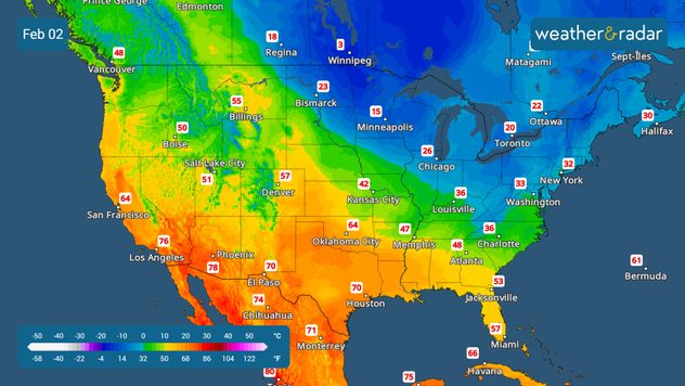
While the cold will be stuck over the East to start the week, temperatures will try to rebound before another cold front arrives again. The west... remains warm!

Cold temperatures will linger across the eastern half of the United States to start the workweek. Low temperatures on Monday morning will fall into the low teens from the Mid-Atlantic through the heart of the Carolinas. Georgia, Alabama, and the northern half of Florida won’t be far behind, with lows dipping into the low to mid-20s.

Monday in the morning.

This cold snap will gradually shift eastward and move out over the Atlantic, allowing warmer air to follow. Meanwhile, warmth will continue to dominate the western half of the country through the week, intensifying by Friday across the Rockies and the Central Plains.

Another cold front is expected to push through the United States toward the end of the week, bringing another drop in temperatures and reinforcing colder air for some areas. While this won’t be as significant as the cold experienced this past weekend, temperatures will still fall a few degrees across Georgia, the Carolinas, and Florida. A few showers will move through the Southeast on Wednesday.

A more noticeable cooldown is expected across the Northeast, where temperatures will once again drop into the single digits starting Thursday and continuing into early next weekend. Highs across upstate New York and parts of the eastern United States will struggle to reach the low teens by next Saturday.

Irene Sans
More on the topic
Record ocean heat halting hurricanes. Strong El Niño influence. . . Sunday, September 13, 2026
A weather map shows a calm Atlantic Ocean with no hurricanes, alongside a picture of the sea.
Sunday, September 13, 2026

Strong El Niño influence

Record ocean heat halting hurricanes
Hurricane parade in the Pacific. Karina is very strong. . Weather Videos. Tuesday, September 1, 2026
WindRadar for Friday, showing the three hurricanes – Lowell, Karina and Maria – over the Pacific.
Weather VideosTuesday, September 1, 2026

Karina is very strong

Hurricane parade in the Pacific
Hawaii's second 2026 hurricane impact. Hurricane Lowell. . . Tuesday, September 8, 2026
Tuesday, September 8, 2026

Hurricane Lowell

Hawaii's second 2026 hurricane impact
All weather news
This might also interest you
Peak season but no activity. Atlantic Basin. . . Thursday, September 10, 2026
A quiet Atlantic at the peak of Atlantic Hurricane Season.
Thursday, September 10, 2026

Atlantic Basin

Peak season but no activity
Rockies cooling off. Seeking a taste of autumn. . . Saturday, September 12, 2026
Saturday, September 12, 2026

Seeking a taste of autumn

Rockies cooling off
1.2K miles of winds, rain & storms. Central & Southwest U.S.. . . Monday, September 14, 2026
Monday, September 14, 2026

Central & Southwest U.S.

1.2K miles of winds, rain & storms
All articles
Weather & Radar

Weather & Radar is also available on

Google Play StoreApp Store

Company

Contact us Privacy policy Legal info Accessibility statement

Services

Uploader

Socials

instagramfacebookthreadslinkList