Home
Weather New York
WeatherRadar
RainRadar
TemperatureRadar
WindRadar
LightningRadar
Weather News
Editor's Pick
Discover the app
Weather widget
Contact us
Apps
Career
    Home / Weather News /

    The North American Monsoon: What is it, and why is it important?

11:00 AM
September 6, 2026

North American Monsoon
What is it, and why is it important?

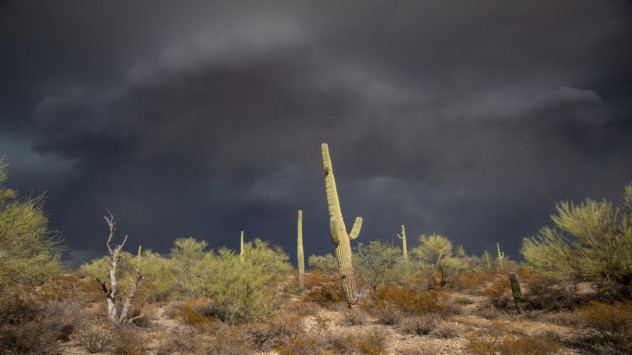
North American Monsoon in the desert

Summer thunderstorms and downpours across the Southwest and Great Basin are often driven by a unique weather pattern.

This meteorological transformation is commonly referred to as the North American Monsoon. Similar to its famous counterpart, the Indian Monsoon, the North American Monsoon is characterized by a seasonal upsurge in precipitation across various parts of the Western United States, including the Desert Southwest. The WeatherRadar is a great to track these storm.

This annual phenomenon occurs during the summer months when prevalent westerly breezes shift to more of a south-to-southeast direction. The flow of air brings moisture up from both the Gulf of Mexico and the Gulf of California, which acts as fuel for showers and thunderstorms.

Northwestern Mexico and the southwestern U.S. receive over half of their annual precipitation during the monsoon season. This rainfall is crucial for the region's plants, animals, and people. In addition, it helps replenish water reservoirs, mitigate drought, and control wildfires during the hottest months of the year. The North American Monsoon, while providing much-needed rainfall to arid regions, also brings its share of dangers. The sudden and intense thunderstorms during the monsoon can lead to flash floods and mudslides, especially in areas with little vegetation to hold the soil.

Additionally, frequent lightning poses a risk of wildfires, which can spread rapidly through dry vegetation. The monsoon can also create hazardous driving conditions with reduced visibility due to blowing dust from thunderstorm gusts.

Overall, while the monsoon is mostly beneficial for water resources, it also presents significant challenges and potential hazards to both human settlements and natural environments in the affected regions.

Weather & Radar USA editorial team
More on the topic
Meteorological vs astronomical autumn. Season start date. . . Tuesday, September 1, 2026
Tuesday, September 1, 2026

Season start date

Meteorological vs astronomical autumn
Hurricane Polo remains dangerous. Active Pacific. . . Thursday, September 24, 2026
Thursday, September 24, 2026

Active Pacific

Hurricane Polo remains dangerous
Hurricane Polo heads for Mexico. Severe weather risk. . . Monday, September 28, 2026
Hurricane Polo is set to make landfall in the Baja-California.
Monday, September 28, 2026

Severe weather risk

Hurricane Polo heads for Mexico
All weather news
This might also interest you
Rounds of rain for Florida. Not so Sunshine State. . . Monday, October 5, 2026
While October typically marks a transition to drier weather in Florida, the first full week of the month is kicking off with heavy rain. But how much rain are we talking about?
Monday, October 5, 2026

Not so Sunshine State

Rounds of rain for Florida
October astro outlook. Look up!. . . Saturday, October 3, 2026
Star gazing - Astro outlook
Saturday, October 3, 2026

Look up!

October astro outlook
40-degree difference over 101 miles. Eureka to Redding. . . Tuesday, October 6, 2026
Tuesday, October 6, 2026

Eureka to Redding

40-degree difference over 101 miles
All articles
Weather & Radar

Weather & Radar is also available on

Google Play StoreApp Store

Company

Contact us Privacy policy Legal info Accessibility statement

Services

Uploader

Socials

instagramfacebookthreadslinkList