Home
Weather New York
WeatherRadar
RainRadar
TemperatureRadar
WindRadar
LightningRadar
Weather News
Editor's Pick
Discover the app
Weather widget
Contact us
Apps
Career
    Home / Weather News /

    Timelapse shows desne fog rolling across Albany, N.Y.

04:19 PM
September 5, 2024

Timelapse footage
Fog rolls across Albany, N.Y.

On Thursday morning, September 5, timelapse footage from the NYS Mesonet at the University of Albany captured fog rolling through Albany, New York.

The fog blanketed the campus before dissipating a few hours later. Local authorities warned motorists of "locally dense" fog. It's no surprise to see fog across Upstate New York. Fall is the Northeast's foggiest season for interior locations.

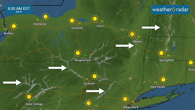
The WeatherRadar shows valley fog forming across the Interior Northeast during the early morning hours of September 5, 2024.

Fog forms when the air cools, and moisture condenses into tiny water droplets near the ground. One of the foggiest places in the U.S. is Cape Disappointment, near Ilwaco, Washington, which experiences over 100 foggy days annually.

How does fog form?read more
Federico Di Catarina
More on the topic
Longest day of the year is here. Summer solstice. . . Sunday, June 21, 2026
Sunday, June 21, 2026

Summer solstice

Longest day of the year is here
Super Typhoon Bavi threatens Taiwan. 155 mph winds. . Weather Videos. Wednesday, July 8, 2026
The image shows an intense tropical cyclone over the western Pacific, east of Taiwan and the Philippines. The centre of the system is depicted as a light purple and white vortex with a clearly visible eye, surrounded by a ring of red and orange areas indicating the strongest wind speeds. A white arrow marks the typhoon’s predicted track towards the north-west, in the direction of Taiwan. To the west of the storm lie the Philippines, with the cities of Manila and Cebu; to the north of these lies Taiwan, with Taipei. Further west, the Chinese coast, including Hong Kong, and parts of Vietnam can be seen. The coloured wind map shows predominantly green areas outside the storm’s core, indicating significantly weaker winds. White streamlines illustrate the typhoon’s anti-clockwise circulation in the Northern Hemisphere. The highest wind speeds are concentrated around the eye of the cyclone.
Weather VideosWednesday, July 8, 2026

155 mph winds

Super Typhoon Bavi threatens Taiwan
Super Typhoon Near the Philippines. Gusts up to 155. . . Tuesday, June 23, 2026
Tuesday, June 23, 2026

Gusts up to 155

Super Typhoon Near the Philippines
All weather news
This might also interest you
Be prepared for wildfires. By using the app. . . Saturday, July 18, 2026
Wildfires can spark anywhere, anytime. The Weather & Radar app can help you determine your area's risk.
Saturday, July 18, 2026

By using the app

Be prepared for wildfires
Up to four feet of storm surge. Gulf Coast soaker. . . Tuesday, July 21, 2026
Tropical storm alerts are active in the app as Bertha continues to churn in the northern Gulf.
Tuesday, July 21, 2026

Gulf Coast soaker

Up to four feet of storm surge
Heat indices soaring. High humidity. . . Saturday, July 25, 2026
Saturday, July 25, 2026

High humidity

Heat indices soaring
All articles
Weather & Radar

Weather & Radar is also available on

Google Play StoreApp Store

Company

Contact us Privacy policy Legal info Accessibility statement

Services

Uploader

Socials

instagramfacebookthreadslinkList