Home
Weather New York
WeatherRadar
RainRadar
TemperatureRadar
WindRadar
LightningRadar
Weather News
Editor's Pick
Discover the app
Weather widget
Contact us
Apps
Career
    Home / Weather News /

    Tornadoes & winds - Intense storms for Upper Midwest metros

02:08 PM
June 11, 2026

Tornadoes & winds
Intense storms for Upper Midwest metros

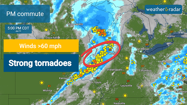
Round two of the storms on Thursday bring a tornado risk with damaging winds and hail.

Another severe weather outbreak is forecast on Thursday for the Midwest, with a focus on places like Davenport, Iowa, Chicago and Peoria, Ill. Severe storms could impact as far south as the Texas Panhandle, with another risk aree defined along the I-95 corridor of the Mid- Atlantic and portions of the Ohio Valley.

More than 600 storm reports were sent to the National Weather Service on Wednesday, with the bulk of them occurring in the Midwest. Today, another round of severe storms brings as much as a moderate risk - a level four out of five on the severity scale - with multiple tornadoes, damaging winds and large hail in the forecast.

Two rounds of storms are expected. The WeatherRadar shows one severe storm cluster in the Midwest that is set to move east through the lunch hour, while round two begins to fire behind it for the afternoon and evening, just in time for the commute for many. Both rounds pose tornado and flash-flood risks.

Further east, a disturbance rolling off of the Ohio Valley and Appalachians could trigger strong to severe storms for more big metro spots like Pittsburgh, New York City, Washington, D.C. and Richmond, Va. Storms could start firing after lunchtime and last through the evening as the disturbance shifts east.

Upload your weather views to the app!read more
Becca Parker
More on the topic
Record-breaking heatwave in Europe. Hotter than most of U.S.. . . Thursday, June 25, 2026
Thursday, June 25, 2026

Hotter than most of U.S.

Record-breaking heatwave in Europe
Super Typhoon Bavi threatens Taiwan. 155 mph winds. . Weather Videos. Wednesday, July 8, 2026
The image shows an intense tropical cyclone over the western Pacific, east of Taiwan and the Philippines. The centre of the system is depicted as a light purple and white vortex with a clearly visible eye, surrounded by a ring of red and orange areas indicating the strongest wind speeds. A white arrow marks the typhoon’s predicted track towards the north-west, in the direction of Taiwan. To the west of the storm lie the Philippines, with the cities of Manila and Cebu; to the north of these lies Taiwan, with Taipei. Further west, the Chinese coast, including Hong Kong, and parts of Vietnam can be seen. The coloured wind map shows predominantly green areas outside the storm’s core, indicating significantly weaker winds. White streamlines illustrate the typhoon’s anti-clockwise circulation in the Northern Hemisphere. The highest wind speeds are concentrated around the eye of the cyclone.
Weather VideosWednesday, July 8, 2026

155 mph winds

Super Typhoon Bavi threatens Taiwan
How does fog form?. Multiple ways. . . Saturday, July 11, 2026
Saturday, July 11, 2026

Multiple ways

How does fog form?
All weather news
This might also interest you
Fireworks and Air Quality. Smoke and pollution. . . Saturday, July 4, 2026
Saturday, July 4, 2026

Smoke and pollution

Fireworks and Air Quality
Follow the clouds. High-pressure ridge. . . Monday, July 13, 2026
Monday, July 13, 2026

High-pressure ridge

Follow the clouds
6 easy steps to take now to be ready. Hurricane preparedness. . . Sunday, July 12, 2026
Are you ready?
Sunday, July 12, 2026

Hurricane preparedness

6 easy steps to take now to be ready
All articles
Weather & Radar

Weather & Radar is also available on

Google Play StoreApp Store

Company

Contact us Privacy policy Legal info Accessibility statement

Services

Uploader

Socials

instagramfacebookthreadslinkList