Home
Weather New York
WeatherRadar
RainRadar
TemperatureRadar
WindRadar
LightningRadar
Weather News
Editor's Pick
Discover the app
Weather widget
Contact us
Apps
Career
    Home / Editor's Pick /

    Tropical update Disturbance in the Caribbean, Pilar’s rain factory

02:08 PM
November 1, 2023

Tropical update
Caribbean system, Pilar’s rain factory

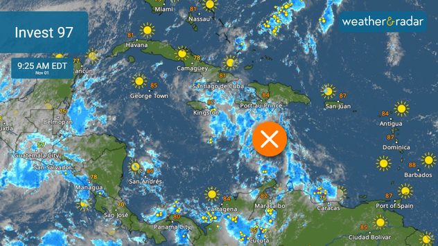
While Pilar continues to produce heavy rains over parts of Central America, rains are also impacting parts of the Caribbean as a trough brings frequent downpours and storms from Puerto Rico, the Dominican Republic, and Haiti. This trough could become better organized later this week and be the next named system of the season. Where would it go?

Invest 97 has caused heavy rains from Puerto Rico to Haiti.

Conditions will become more favorable for a trough to deepen and take on tropical characteristics over the Caribbean. We forecast it to continue moving slowly west and by the end of the week, it could become Vince. Honduras and Nicaragua will be soaked and flooding will be possible. Residents and visitors to these countries must be attentive to the evolution of this system and take necessary precautionary measures.

Pilar still doesn't move... much.

Over the Eastern Pacific, Pilar has been moving slowly north, approaching the coast of El Salvador. The system itself has not had much movement this week, which means that the rains will not stop for Guatemala, El Salvador, and Honduras. Landslides and multiple floods have been recorded in several sectors.

Flooding and landslides will continue to be likely as Pilar heads west, slowly moving away from El Salvador (finally) this Thursday. Pilar is expected to continue as a tropical storm, even as it moves away from Central America.

Accumulations of 10 inches will be probable for parts of El Salvador, Honduras, western Nicaragua, and even the northern part of Costa Rica. Some areas can accumulate up to 15 inches of rain. Flash floods are likely, with a high risk of landslides as well.

We will continue to monitor closely what happens in the tropics, since Central America, the same areas that have been stalked by Pilar, will have abundant tropical humidity again due to the system that will arrive from the Caribbean. You can use our WeatherRadar to see how the storms will be affecting these regions.

Irene Sans
More on the topic
The average first frosts in the U.S.. Meteorological autumn. . . Sunday, October 4, 2026
First frosts can begin in September as autumn temps move in.
Sunday, October 4, 2026

Meteorological autumn

The average first frosts in the U.S.
Hurricane Polo remains dangerous. Active Pacific. . . Thursday, September 24, 2026
Thursday, September 24, 2026

Active Pacific

Hurricane Polo remains dangerous
How does fog form?. Multiple ways. . . Saturday, September 12, 2026
Saturday, September 12, 2026

Multiple ways

How does fog form?
All weather news
This might also interest you
Spring Tides: Flooding, Road Closures. Happening along coasts. . . Tuesday, September 29, 2026
Tuesday, September 29, 2026

Happening along coasts

Spring Tides: Flooding, Road Closures
Autumn foliage: weather's impact. Leaf-peeping season!. . . Sunday, October 4, 2026
Cool nights can help intensify autumn foliage color!
Sunday, October 4, 2026

Leaf-peeping season!

Autumn foliage: weather's impact
Hurricane drought in the Atlantic. 352 days and counting. . . Wednesday, September 30, 2026
The last hurricane to form in the Atlantic was Hurricane Melissa on October 13, 2025, 352 days ago. So what's responsible for this hurricane drought?
Wednesday, September 30, 2026

352 days and counting

Hurricane drought in the Atlantic
All articles
Weather & Radar

Weather & Radar is also available on

Google Play StoreApp Store

Company

Contact us Privacy policy Legal info Accessibility statement

Services

Uploader

Socials

instagramfacebookthreadslinkList