Home
Weather New York
WeatherRadar
RainRadar
TemperatureRadar
WindRadar
LightningRadar
Weather News
Editor's Pick
Discover the app
Weather widget
Contact us
Apps
Career
    Home / Editor's Pick /

    Tropical update Disturbance in the Caribbean, Pilar’s rain factory

02:08 PM
November 1, 2023

Tropical update
Caribbean system, Pilar’s rain factory

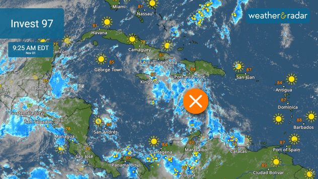
While Pilar continues to produce heavy rains over parts of Central America, rains are also impacting parts of the Caribbean as a trough brings frequent downpours and storms from Puerto Rico, the Dominican Republic, and Haiti. This trough could become better organized later this week and be the next named system of the season. Where would it go?

Invest 97 has caused heavy rains from Puerto Rico to Haiti.

Conditions will become more favorable for a trough to deepen and take on tropical characteristics over the Caribbean. We forecast it to continue moving slowly west and by the end of the week, it could become Vince. Honduras and Nicaragua will be soaked and flooding will be possible. Residents and visitors to these countries must be attentive to the evolution of this system and take necessary precautionary measures.

Pilar still doesn't move... much.

Over the Eastern Pacific, Pilar has been moving slowly north, approaching the coast of El Salvador. The system itself has not had much movement this week, which means that the rains will not stop for Guatemala, El Salvador, and Honduras. Landslides and multiple floods have been recorded in several sectors.

Flooding and landslides will continue to be likely as Pilar heads west, slowly moving away from El Salvador (finally) this Thursday. Pilar is expected to continue as a tropical storm, even as it moves away from Central America.

Accumulations of 10 inches will be probable for parts of El Salvador, Honduras, western Nicaragua, and even the northern part of Costa Rica. Some areas can accumulate up to 15 inches of rain. Flash floods are likely, with a high risk of landslides as well.

We will continue to monitor closely what happens in the tropics, since Central America, the same areas that have been stalked by Pilar, will have abundant tropical humidity again due to the system that will arrive from the Caribbean. You can use our WeatherRadar to see how the storms will be affecting these regions.

Irene Sans
More on the topic
Saturday, May 2, 2026

May astronomy outlook

The only Blue Moon of the year rises
Monday, April 13, 2026

On the WeatherRadar

A cloud of Saharan dust over the Mediterranean
A young woman is kneeling in a cornfield, tending to her plants
Sunday, April 26, 2026

WMO report

Heat is affecting agriculture globally
All weather news
This might also interest you
Severe weather is expected to develop across the central Plains and Midwest this afternoon and evening, with the most significant risk being centered across the central Plains.
Monday, May 18, 2026

Strong tornadoes possible

Severe outbreak in the Plains
Wednesday, May 20, 2026

Texas, South & East

WeatherRadar shows heavy rains
Saturday rainfall
Saturday, May 23, 2026

Flood danger increases

Downpours soak Texas, South
All articles
Weather & Radar

Weather & Radar is also available on

Google Play StoreApp Store

Company

Contact us Privacy policy Legal info Accessibility statement

Services

Uploader

Socials

instagramfacebookthreadslinkList