Home
Weather New York
WeatherRadar
RainRadar
TemperatureRadar
WindRadar
LightningRadar
Weather News
Editor's Pick
Discover the app
Weather widget
Contact us
Apps
Career
    Home / Editor's Pick /

    Tropical update: Goodbye Bret, Cindy’s still kicking!

05:21 AM
June 25, 2023

Tropical update
Goodbye Bret, Cindy’s still kicking!

Tropical Storm Bret has dissipated, but Tropical Storm Cindy will be full of surprises this coming week as it battles with a spot of strong wind shear temporarily.

Tropical Storm Bret’s last official advisory was Saturday afternoon as it became an open trough, it no longer will be a tropical system but its remnants are bringing showers to parts of Central America starting on Sunday into early next week.

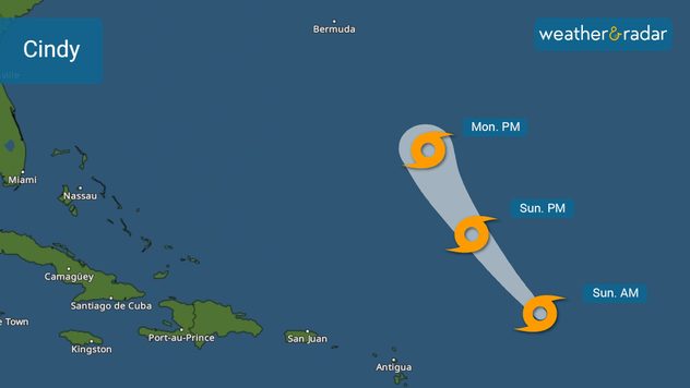
Tropical Storm Cindy track issued late Saturday evening.

Tropical Storm Cindy is still alive

As we mentioned in Friday’s update, Tropical Storm Cindy has stayed well away from the northeastern portion of the Lesser Antilles. This system is not expected to come close to the eastern Caribbean islands as it is moving northwest at 17 mph.

Cindy has and will continue to battle against strong shear in the areas where the system is moving through. Cindy should continue to gradually weaken at least through late Monday night. It is likely that the tropical storm will be downgraded to a tropical wave or just a broad area of low pressure. By mid to late week, there is the chance that Cindy could come back alive and gain strength again, acquiring tropical storm status just as it passes east of Bermuda. This is because in this region, the wind shear will decrease, and there is plenty of warm water to allow the remnants of Cindy to become better organized and gain strength, again.

Hazards highly depend on your locationread more

This part can't be mapped out on the cone as the cone only extends through Monday until this system is expected to be a tropical storm before its downgrade. Once (and if) the system reemerges, then It would also be name Cindy and a forecast, along with a new cone will be issued.

Parts of southeastern Canada should monitor the reemergence of Cindy as it could come close late next week into the weekend.

Is there something else out there?

Great news! The tropics, aside from Cindy, seem to take a break this coming week. There is plenty of dry and dusty air coming out of Africa, which will put a temporary lid on tropical storm formation over the eastern Atlantic… more typical for the month of June.

Irene Sans
More on the topic
Hurricane Polo remains dangerous. Active Pacific. . . Thursday, September 24, 2026
Thursday, September 24, 2026

Active Pacific

Hurricane Polo remains dangerous
10 facts about fog. Low clouds. . . Sunday, September 27, 2026
Fog impacting the Appalachian Mountains.
Sunday, September 27, 2026

Low clouds

10 facts about fog
The average first frosts in the U.S.. Meteorological autumn. . . Sunday, October 4, 2026
First frosts can begin in September as autumn temps move in.
Sunday, October 4, 2026

Meteorological autumn

The average first frosts in the U.S.
All weather news
This might also interest you
Useful tips when driving in the rain. Flood safety. . . Saturday, October 3, 2026
Saturday, October 3, 2026

Flood safety

Useful tips when driving in the rain
Merging storms to bring record rain. Southwest, Plains. . . Tuesday, September 29, 2026
Heavy rainfall is expected across the Plains and Southwest, with flash flooding possible.
Tuesday, September 29, 2026

Southwest, Plains

Merging storms to bring record rain
40-degree difference over 101 miles. Eureka to Redding. . . Tuesday, October 6, 2026
Tuesday, October 6, 2026

Eureka to Redding

40-degree difference over 101 miles
All articles
Weather & Radar

Weather & Radar is also available on

Google Play StoreApp Store

Company

Contact us Privacy policy Legal info Accessibility statement

Services

Uploader

Socials

instagramfacebookthreadslinkList