Home
Weather New York
WeatherRadar
RainRadar
TemperatureRadar
WindRadar
LightningRadar
Weather News
Editor's Pick
Discover the app
Weather widget
Contact us
Apps
Career
    Home / Weather News /

    Tropical update - Invest 94 & another wave moving west

06:02 PM
June 27, 2024

Tropical update
Invest 94 & another wave moving west

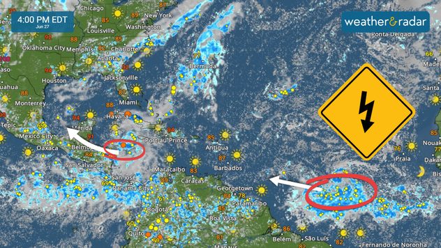
We are looking beyond the deep layer of Saharan Dust present over much of the Caribbean and at two tropical waves, one of which has a high chance of development.

A robust tropical wave located a few hundred miles west-southwest of the Cabo Verde islands continues to travel westward. In the short term, this tropical wave is battling dry air and a little dust from Thursday to Saturday. But in the latter part of the weekend, as the system approaches the Caribbean, conditions will become more favorable for this system to develop into a tropical depression or tropical storm. The National Hurricane Center gives it a high chance of developing through the next seven days.

Two tropical waves with chance of development within the next 7 days.

Invest 94L

Another area we monitor is a tropical wave moving west-northwest in the western Caribbean. This system will move over the Gulf of Honduras and likely emerge over the southern Gulf of Mexico early this weekend. It is here where conditions will be momentarily more favorable for it to become a tropical depression or storm.

It will remain close to land and likely directly impact the states of Veracruz or Tamaulipas, areas recently affected by Tropical Storm Alberto’s heavy rains. The team of meteorologists at Weather and Radar will continue to monitor the tropics and bring you frequent updates.

Irene Sans
More on the topic
Super Typhoon Near the Philippines. Gusts up to 155. . . Tuesday, June 23, 2026
Tuesday, June 23, 2026

Gusts up to 155

Super Typhoon Near the Philippines
How does fog form?. Multiple ways. . . Saturday, July 11, 2026
Saturday, July 11, 2026

Multiple ways

How does fog form?
Super Typhoon Bavi threatens Taiwan. 155 mph winds. . Weather Videos. Wednesday, July 8, 2026
The image shows an intense tropical cyclone over the western Pacific, east of Taiwan and the Philippines. The centre of the system is depicted as a light purple and white vortex with a clearly visible eye, surrounded by a ring of red and orange areas indicating the strongest wind speeds. A white arrow marks the typhoon’s predicted track towards the north-west, in the direction of Taiwan. To the west of the storm lie the Philippines, with the cities of Manila and Cebu; to the north of these lies Taiwan, with Taipei. Further west, the Chinese coast, including Hong Kong, and parts of Vietnam can be seen. The coloured wind map shows predominantly green areas outside the storm’s core, indicating significantly weaker winds. White streamlines illustrate the typhoon’s anti-clockwise circulation in the Northern Hemisphere. The highest wind speeds are concentrated around the eye of the cyclone.
Weather VideosWednesday, July 8, 2026

155 mph winds

Super Typhoon Bavi threatens Taiwan
All weather news
This might also interest you
Flooding rains shift north along I-95. 5 inches more. . . Wednesday, July 29, 2026
Extreme weather alerts are active as heavy rain could cause flooding issues.
Wednesday, July 29, 2026

5 inches more

Flooding rains shift north along I-95
Three common misperceptions. Hurricane season. . . Sunday, August 2, 2026
Hurricane Ian (2022) satellite imagery before SWFL landfall.
Sunday, August 2, 2026

Hurricane season

Three common misperceptions
Dry vegetation, low humidity and winds. The perfect fire recipe. . . Sunday, July 26, 2026
Sunday, July 26, 2026

The perfect fire recipe

Dry vegetation, low humidity and winds
All articles
Weather & Radar

Weather & Radar is also available on

Google Play StoreApp Store

Company

Contact us Privacy policy Legal info Accessibility statement

Services

Uploader

Socials

instagramfacebookthreadslinkList