Home
Weather New York
WeatherRadar
RainRadar
TemperatureRadar
WindRadar
LightningRadar
Weather News
Editor's Pick
Discover the app
Weather widget
Contact us
Apps
Career
    Home / Editor's Pick /

    Tropical update: Philippe: Flash flood risk continues for NE Caribbean

03:21 PM
October 4, 2023

Tropical update
Philippe: Flash floods for NE Caribbean

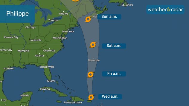
Tropical Storm Philippe continues to batter the eastern Caribbean with heavy rains, which have caused life-threatening flooding. Tropical watches might be issued for Bermuda later today as Philippe slowly moves away from the Caribbean to the north. Residents across the northern Northeast and southeastern Canada should monitor the Philippe as it could come close or make landfall this weekend.

Philippe's track issued by the NHC on Wednesday morning.

The center of Tropical Storm Philippe is located about 120 miles north of Puerto Rico, but the strongest thunderstorms and gusty winds are displaced to the south and east due to wind shear interacting with this system. Philippe is moving slowly, so heavy rains and high flooding risk will continue for the U.S. and British Virgin Islands. Eastern Puerto Rico and smaller islands like Vieques and Culebra can also expect strong thunderstorms and gusty winds, and additional rainfall up to 2 more inches. Southeastern regions of Puerto Rico could receive up to 4 inches of rain.

Rough seas will continue to affect the northeastern Caribbean. Boaters should avoid going out to sea, especially those in small crafts.

Long-term forecast

The weekend forecast regarding Philippe is still not set in stone, as there will be small fluctuations that could bring bigger changes, for good or worse. We do know that there is a good chance for Philippe to turn to the north-northwest after passing Bermuda. This small turn could take Philippe anywhere between New England and southeastern Canada as a tropical storm. Residents in the region should monitor the evolution of Philippe closely as it could potentially bring an active weekend, likely Sunday, filled with storm bands and strong winds.

We will continue monitoring the tropics closely and bring you prompt updates on our app and Weather&Radar.com

**This same information can be seen in Spanish, written by our meteorologists, only by configuring our application to Spanish. Tell your family and friends that you only speak Spanish, so they too are informed, and stay safe, please. **

Irene Sans
More on the topic
Hurricane Polo heads for Mexico. Severe weather risk. . . Monday, September 28, 2026
Hurricane Polo is set to make landfall in the Baja-California.
Monday, September 28, 2026

Severe weather risk

Hurricane Polo heads for Mexico
The average first frosts in the U.S.. Meteorological autumn. . . Sunday, October 4, 2026
First frosts can begin in September as autumn temps move in.
Sunday, October 4, 2026

Meteorological autumn

The average first frosts in the U.S.
Hurricane Polo remains dangerous. Active Pacific. . . Thursday, September 24, 2026
Thursday, September 24, 2026

Active Pacific

Hurricane Polo remains dangerous
All weather news
This might also interest you
Useful tips when driving in the rain. Flood safety. . . Saturday, October 3, 2026
Saturday, October 3, 2026

Flood safety

Useful tips when driving in the rain
Autumn foliage: weather's impact. Leaf-peeping season!. . . Sunday, October 4, 2026
Cool nights can help intensify autumn foliage color!
Sunday, October 4, 2026

Leaf-peeping season!

Autumn foliage: weather's impact
1,800 miles of rain. From Texas to Michigan. . . Thursday, October 1, 2026
Thursday, October 1, 2026

From Texas to Michigan

1,800 miles of rain
All articles
Weather & Radar

Weather & Radar is also available on

Google Play StoreApp Store

Company

Contact us Privacy policy Legal info Accessibility statement

Services

Uploader

Socials

instagramfacebookthreadslinkList