Home
Weather New York
WeatherRadar
RainRadar
TemperatureRadar
WindRadar
LightningRadar
Weather News
Editor's Pick
Discover the app
Weather widget
Contact us
Apps
Career
    Home / Editor's Pick /

    Tropical update: Tropical Storm Karl forms in the Gulf

01:21 PM
October 11, 2022

No threat to U.S.
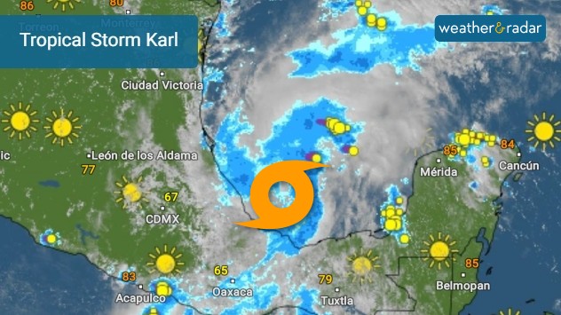
Tropical Storm Karl forms in the Gulf

Tropical Storm Karl has formed in the Bay of Campeche

As of Tuesday afternoon, Tropical Storm Karl formed in the Bay of Campeche.

Remember Hurricane Julia? The hurricane that made landfall in Nicaragua and crossed over to the Pacific as a tropical storm? Well, some of the remnants made their way north into the Bay of Campeche, helping to form Tropical Storm Karl.

Privacy policy

The cluster of storms emerged over the Bay of Campeche overnight and Tuesday morning before becoming more organized. There is not much time for Karl to be over water and the upper-level winds will be strong which will inhibit this cluster of storms from organizing further. Karl is not a threat to the U.S. and will eventually be pushed into Veracruz Thursday into Friday.

Heavy rains are forecast to continue across southern Mexico with the chance of flooding.

Anything else out there?

We are closing in on the last few weeks of hurricane season. Although there could be tropical waves still emerging from Africa, the areas more prone to development in October and November are closer to land. Fronts are starting to make their way south and there are times that they leave lingering energy behind over the Gulf of Mexico or across the western Atlantic closer to the East Coast.

We will continue to monitor the tropics closer and bring you prompt updates.

Irene Sans
Becca Parker
More on the topic
How does fog form?. Multiple ways. . . Saturday, July 11, 2026
Saturday, July 11, 2026

Multiple ways

How does fog form?
Super Typhoon Bavi threatens Taiwan. 155 mph winds. . Weather Videos. Wednesday, July 8, 2026
The image shows an intense tropical cyclone over the western Pacific, east of Taiwan and the Philippines. The centre of the system is depicted as a light purple and white vortex with a clearly visible eye, surrounded by a ring of red and orange areas indicating the strongest wind speeds. A white arrow marks the typhoon’s predicted track towards the north-west, in the direction of Taiwan. To the west of the storm lie the Philippines, with the cities of Manila and Cebu; to the north of these lies Taiwan, with Taipei. Further west, the Chinese coast, including Hong Kong, and parts of Vietnam can be seen. The coloured wind map shows predominantly green areas outside the storm’s core, indicating significantly weaker winds. White streamlines illustrate the typhoon’s anti-clockwise circulation in the Northern Hemisphere. The highest wind speeds are concentrated around the eye of the cyclone.
Weather VideosWednesday, July 8, 2026

155 mph winds

Super Typhoon Bavi threatens Taiwan
Europe: Warmest June on record. Warm waters too. . . Friday, July 10, 2026
The record-breaking heatwave in June has made climate history in Western Europe.
Friday, July 10, 2026

Warm waters too

Europe: Warmest June on record
All weather news
This might also interest you
Heat indices soaring. High humidity. . . Saturday, July 25, 2026
Saturday, July 25, 2026

High humidity

Heat indices soaring
When severe storms strike.... You can be ready. . . Sunday, July 26, 2026
Sunday, July 26, 2026

You can be ready

When severe storms strike...
Intense rain for the Northeast. Flooding possible. . . Tuesday, July 28, 2026
Tuesday, July 28, 2026

Flooding possible

Intense rain for the Northeast
All articles
Weather & Radar

Weather & Radar is also available on

Google Play StoreApp Store

Company

Contact us Privacy policy Legal info Accessibility statement

Services

Uploader

Socials

instagramfacebookthreadslinkList