Home
Weather New York
WeatherRadar
RainRadar
TemperatureRadar
WindRadar
LightningRadar
Weather News
Editor's Pick
Discover the app
Weather widget
Contact us
Apps
Career
    Home / Editor's Pick /

    Weather & Radar storm chaser's Blog with Jonathan Petramala

11:00 PM
July 18, 2024

Storm chaser's Blog
On the frontlines of extreme weather

Recommended external content from YouTube

We need your consent to show content from YouTube. You can withdraw your consent at any time.
I agree that content from YouTube will be displayed to me.
Privacy policy

Weather & Radar's Jonathan Petramala is a seasoned journalist specializing in extreme weather. Here’s an account of his most impactful storm encounters and experiences.

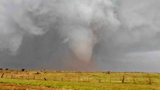
Jonathan has been a professional journalist for over 20 years and shifted his focus to extreme weather and storytelling in 2018. Since then, he has chased a variety of events, including flash floods, tornadoes, and hurricanes. His first tornado chase was in Tescott, Kansas, in May 2018 during a severe weather outbreak, and he intercepted his first major hurricane, Hurricane Florence, later that same year.

during a severe weather outbreak
© Jonathan Petramala

“Documenting these events is crucial for fostering empathy and mobilizing aid. My coverage often directly leads to volunteer and support efforts, making the risks worthwhile,” explains Petramala.

Did you know?

You can be part of the action by sharing your weather images with Weather & Radar with the uploader. Storm chaser or not, we love to see your beautiful nature photos.

One of Jonathan's proudest moments was during Hurricane Beryl in Carriacou in June 2024. He and his colleague, Brandon Clement, were the only journalists on the island and provided critical communication and insight into the devastation. Their reports helped coordinate emergency responses and facilitated rapid aid delivery, including bringing Starlink terminals to restore communication.

While extensive preparation minimizes fear, there are still dangers. During Hurricane Beryl, the roof of their shelter was torn off, exposing them to flying debris and gusts over 140 mph. Staying calm, they relocated to safety, ensuring they could continue their vital work. Another adrenaline-filled moment occurred on May 3, 2024, when an erratically moving tornado and lack of radar service put Jonathan in a tight spot, relying on visual cues and last-minute decisions to steer clear of the tornado.

Any good storm chaser should know theseTornado myths

Weather & Radar is proud to have Jonathan on the team. His excellent journalism helps us reach out to our users and give them a firsthand and timely look at the exciting world of weather. You can follow Jonathan's content on Weather & Radar by checking our news stream on the app. If you always want to receive Jonathan's most exciting coverage, turn on your news alerts in the settings!

Federico Di Catarina
More on the topic
Super Typhoon Bavi threatens Taiwan. 155 mph winds. . Weather Videos. Wednesday, July 8, 2026
The image shows an intense tropical cyclone over the western Pacific, east of Taiwan and the Philippines. The centre of the system is depicted as a light purple and white vortex with a clearly visible eye, surrounded by a ring of red and orange areas indicating the strongest wind speeds. A white arrow marks the typhoon’s predicted track towards the north-west, in the direction of Taiwan. To the west of the storm lie the Philippines, with the cities of Manila and Cebu; to the north of these lies Taiwan, with Taipei. Further west, the Chinese coast, including Hong Kong, and parts of Vietnam can be seen. The coloured wind map shows predominantly green areas outside the storm’s core, indicating significantly weaker winds. White streamlines illustrate the typhoon’s anti-clockwise circulation in the Northern Hemisphere. The highest wind speeds are concentrated around the eye of the cyclone.
Weather VideosWednesday, July 8, 2026

155 mph winds

Super Typhoon Bavi threatens Taiwan
High pressure & extreme heat. Why & how does it work?. . . Sunday, July 12, 2026
Sunday, July 12, 2026

Why & how does it work?

High pressure & extreme heat
How does fog form?. Multiple ways. . . Saturday, July 11, 2026
Saturday, July 11, 2026

Multiple ways

How does fog form?
All weather news
This might also interest you
Be prepared for wildfires. By using the app. . . Saturday, July 18, 2026
Wildfires can spark anywhere, anytime. The Weather & Radar app can help you determine your area's risk.
Saturday, July 18, 2026

By using the app

Be prepared for wildfires
How does a hurricane form?. Hurricane preparedness. . . Sunday, July 19, 2026
hurricane maria
Sunday, July 19, 2026

Hurricane preparedness

How does a hurricane form?
Multi-Day flood threat for Mid-Atlantic. Stalled front. . . Wednesday, July 22, 2026
Wednesday, July 22, 2026

Stalled front

Multi-Day flood threat for Mid-Atlantic
All articles
Weather & Radar

Weather & Radar is also available on

Google Play StoreApp Store

Company

Contact us Privacy policy Legal info Accessibility statement

Services

Uploader

Socials

instagramfacebookthreadslinkList