Home
Weather New York
WeatherRadar
RainRadar
TemperatureRadar
WindRadar
LightningRadar
Weather News
Editor's Pick
Discover the app
Weather widget
Contact us
Apps
Career
    Home / Editor's Pick /

    Wedneday’s severe forecast: One dead in Kansas as severe weather rips through

10:00 AM
May 1, 2024

Severe storms Wednesday
1 dead in Kansas as storms ripped thru

Tuesday night severe storms ripped through Westmoreland, Kan., killing one person. The severe weather continues Wednesday with nearly 1 million people under an enhanced risk.

Tuesday was another day where severe storms made history. In the town of Westmoreland in Kansas, about 45 miles west of Topeka, with a population of about 700, a tornado destroyed 22 homes, RVs and damaged businesses and buildings. The severe storms left the city without power as rescuers continued to search for any other people who could have been trapped in the rubble.

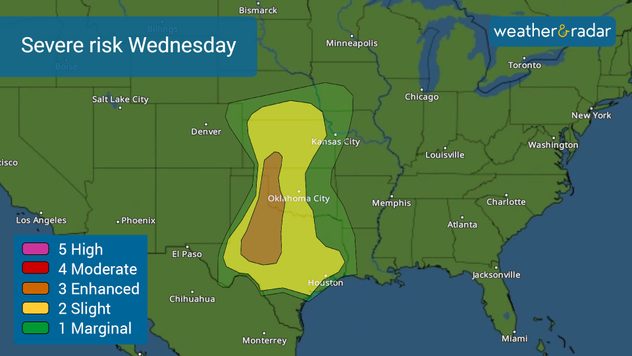
Severe risk for Wednesday.

The severe forecast for Wednesday

Severe storms target the southern Plains on Wednesday. The highest risk, level 3 of 5, enhanced covers parts of Oklahoma and western Texas, including Abilene, Texas, and San Angelo, Texas, through Altus Okla. The slight risk, where there could also be large hail, damaging wind, and a couple of tornadoes covers a much larger area, over 22 million people are at a slight risk.

Houston, Dallas-Fort Worth, Austin, San Antonio through Oklahoma City are all highlighted in yellow in the map. This is all part of the next low-pressure system exiting the Rockies and a low-pressure system in the upper levels of the atmosphere that will allow for numerous severe storms to develop mainly between 4 p.m. and 3 a.m.

Watch our live storm chase from Wednesday, May 1, 2024:

Thursday morning will be a wet and stormy one across eastern Texas, with some strong thunderstorms affecting I-45 from Oklahoma City southward to Houston. Louisiana will also experience storms most of Thursday.

Make sure your weather alerts are on if you are in areas highlighted in yellow or orange in the maps above. Stay informed with the latest weather information for your area and track the storms’ movement using our WeatherRadar.

Irene Sans
More on the topic
Record ocean heat halting hurricanes. Strong El Niño influence. . . Sunday, September 13, 2026
A weather map shows a calm Atlantic Ocean with no hurricanes, alongside a picture of the sea.
Sunday, September 13, 2026

Strong El Niño influence

Record ocean heat halting hurricanes
Meteorological vs astronomical autumn. Season start date. . . Tuesday, September 1, 2026
Tuesday, September 1, 2026

Season start date

Meteorological vs astronomical autumn
Hurricane Polo heads for Mexico. Severe weather risk. . . Monday, September 28, 2026
Hurricane Polo is set to make landfall in the Baja-California.
Monday, September 28, 2026

Severe weather risk

Hurricane Polo heads for Mexico
All weather news
This might also interest you
Autumn cold front arrives. October cooldown spreads. . . Friday, October 2, 2026
Cold front brings cooler temperatures.
Friday, October 2, 2026

October cooldown spreads

Autumn cold front arrives
October astro outlook. Look up!. . . Saturday, October 3, 2026
Star gazing - Astro outlook
Saturday, October 3, 2026

Look up!

October astro outlook
40-degree difference over 101 miles. Eureka to Redding. . . Tuesday, October 6, 2026
Tuesday, October 6, 2026

Eureka to Redding

40-degree difference over 101 miles
All articles
Weather & Radar

Weather & Radar is also available on

Google Play StoreApp Store

Company

Contact us Privacy policy Legal info Accessibility statement

Services

Uploader

Socials

instagramfacebookthreadslinkList