Home
Weather New York
WeatherRadar
RainRadar
TemperatureRadar
WindRadar
LightningRadar
Weather News
Editor's Pick
Discover the app
Weather widget
Contact us
Apps
Career
    Home / Weather News /

    What does it mean? - La Niña's winter is likely

03:21 PM
October 22, 2024

What does it mean?
La Niña's winter is likely

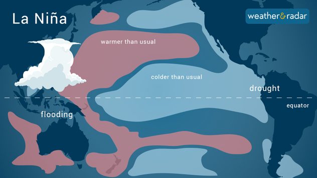
What happens in the La Nina phase.
What happens in the La Niña phase?

La Niña has a 60 percent chance of being present for the winter of 2024-2025. It would be a weak La Niña, which would bring a caveat.

La Niña is the counterpart of the El Niño Southern Oscillation (ENSO). It brings cooler-than-normal sea surface water temperatures to a certain spot over the tropical Pacific Ocean. The cooling, in this certain area, causes alterations all across the globe, and depending on the time of year it forms, it can mean more or less of your favorite weather conditions.

As the National Oceanic and Atmospheric Administration, NOAA, forecasts, a weak La Niña will likely reign the winter. Under a typical La Niña, the jetstream is displaced a bit more north, which channels storms across the northern half of the United States, and the south tends to be influenced by higher pressures, which keeps the winter drier and warmer than usual from California through the Southeast.

Since the forecast calls for a weak La Niña, there could be more fluctuations to this forecast, meaning more variability. When there is a weak La Niña, Nor'easters tend to stay inland, which could mean less snow overall for the tri-state region but more liquid and icy precipitation. Similar conditions are expected for the mid-Atlantic area.

Remember that this doesn't mean that some storms won't make it down south. Some cold outbreaks could still occur, but these tend to be less frequent under a La Niña. There will still be some cold days and perhaps some places receiving snow, so don't rule out bringing those jackets and winter gear. You might not use them too much, but they will be used for sure at some point this winter if you are in the south. If you read us from "up-north," you can bet on a colder and snowier, rainier season if you are anywhere from the Pacific Northwest through the Great Lakes area.

Irene Sans
More on the topic
Record-breaking heatwave in Europe. Hotter than most of U.S.. . . Thursday, June 25, 2026
Thursday, June 25, 2026

Hotter than most of U.S.

Record-breaking heatwave in Europe
Rip currents & safety tips. As more head to the coast. . . Saturday, July 25, 2026
rip current
Saturday, July 25, 2026

As more head to the coast

Rip currents & safety tips
Super Typhoon Bavi threatens Taiwan. 155 mph winds. . Weather Videos. Wednesday, July 8, 2026
The image shows an intense tropical cyclone over the western Pacific, east of Taiwan and the Philippines. The centre of the system is depicted as a light purple and white vortex with a clearly visible eye, surrounded by a ring of red and orange areas indicating the strongest wind speeds. A white arrow marks the typhoon’s predicted track towards the north-west, in the direction of Taiwan. To the west of the storm lie the Philippines, with the cities of Manila and Cebu; to the north of these lies Taiwan, with Taipei. Further west, the Chinese coast, including Hong Kong, and parts of Vietnam can be seen. The coloured wind map shows predominantly green areas outside the storm’s core, indicating significantly weaker winds. White streamlines illustrate the typhoon’s anti-clockwise circulation in the Northern Hemisphere. The highest wind speeds are concentrated around the eye of the cyclone.
Weather VideosWednesday, July 8, 2026

155 mph winds

Super Typhoon Bavi threatens Taiwan
All weather news
This might also interest you
Three common misperceptions. Hurricane season. . . Sunday, August 2, 2026
Hurricane Ian (2022) satellite imagery before SWFL landfall.
Sunday, August 2, 2026

Hurricane season

Three common misperceptions
Moisture surge fuels strong storms. Northeast deluge. . . Friday, August 7, 2026
Friday, August 7, 2026

Northeast deluge

Moisture surge fuels strong storms
The meeting of the wet masses. A Florida story. . . Wednesday, August 5, 2026
Two air masses conerge to produce storms & heavy downpours across the Florida Peninsula today.
Wednesday, August 5, 2026

A Florida story

The meeting of the wet masses
All articles
Weather & Radar

Weather & Radar is also available on

Google Play StoreApp Store

Company

Contact us Privacy policy Legal info Accessibility statement

Services

Uploader

Socials

instagramfacebookthreadslinkList