Home
Weather New York
WeatherRadar
RainRadar
TemperatureRadar
WindRadar
LightningRadar
Weather News
Editor's Pick
Discover the app
Weather widget
Contact us
Apps
Career
    Home / Editor's Pick /

    Why & how does it work? High pressure & extreme heat

12:00 PM
July 12, 2026

Why & how does it work?
High pressure & extreme heat

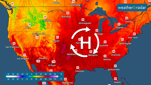
A high-pressure system in the upper atmosphere is to blame for the extreme heat that can occur in the summer.

Prolonged extreme temperatures are often due to the infamous dome of high pressure, which could stay in the same place for several days to a couple of weeks. Why do these pesky high pressures often bring so much heat for an extensive time? We got the answer for you!

Europe's record-breaking heatread more

High-pressure systems bring sinking air. The air dries and warms as it sinks, and with a blocking pattern, this heat can stay for several days or even weeks, keeping the A.C. running.

Temperatures increase in the eastern half as a high pressure settles in.

Keep an eye on the TemperatureRadar, especailly through these heatwaves, to know when the hottest part of the day will be. For some, nighttime relief will be hard to come by.

Irene Sans
More on the topic
What are weather fronts?. Weather explained. . . Sunday, August 23, 2026
Image of a temperature radar showing a clear distinction between a warm and cold air mass separated by a cold front.
Sunday, August 23, 2026

Weather explained

What are weather fronts?
Record ocean heat halting hurricanes. Strong El Niño influence. . . Sunday, September 13, 2026
A weather map shows a calm Atlantic Ocean with no hurricanes, alongside a picture of the sea.
Sunday, September 13, 2026

Strong El Niño influence

Record ocean heat halting hurricanes
All about nocturnal severe weather. Risks & preparedness. . . Saturday, September 5, 2026
Saturday, September 5, 2026

Risks & preparedness

All about nocturnal severe weather
All weather news
This might also interest you
An Autumn Change for Florida. Dry air and strong winds. . . Tuesday, September 15, 2026
Tuesday, September 15, 2026

Dry air and strong winds

An Autumn Change for Florida
30-degree drop on heels of equinox. Mid-Atlantic & Southeast. . . Monday, September 21, 2026
Monday, September 21, 2026

Mid-Atlantic & Southeast

30-degree drop on heels of equinox
What's supercharing the monsoon. Flash flood threat. . . Wednesday, September 16, 2026
If you look at the WeatherRadar, you will see a supercharged monsoon with even heavier downpours than usual. So what's behind this surge of moisture?
Wednesday, September 16, 2026

Flash flood threat

What's supercharing the monsoon
All articles
Weather & Radar

Weather & Radar is also available on

Google Play StoreApp Store

Company

Contact us Privacy policy Legal info Accessibility statement

Services

Uploader

Socials

instagramfacebookthreadslinkList