Home
Weather New York
WeatherRadar
RainRadar
TemperatureRadar
WindRadar
LightningRadar
Weather News
Editor's Pick
Discover the app
Weather widget
Contact us
Apps
Career
    Home / Weather News /

    Winter storm: Power outages, snow, ice & severe storms

05:28 PM
January 25, 2026

Weekend winter storm
Power outages, snow, ice & severe storms

The major winter storm peaks today, bringing heavy snow, frigid cold, ice and even severe weather for much of the eastern half of the U.S. Many are without power after Saturday's impacts already.

As of Noon ET Sunday, almost one million customers are without power from Texas to Virginia, with more than a quarter of those outages being across Tennessee. Many across the Deep South have seen dangerous ice accretions, causing tree limbs to fall and electrical fires. Ice totals between 0.50 and 0.75 inches have been reported in Texas, Oklahoma, Louisiana and Mississippi. It only takes 0.25 inches to cause major tree damage.

The winter storm will move to the northeast throughout the day on Sunday, with severe storms, including tornadoes and damaging gusts, possible along the Gulf Coast from New Orleans through the Florida Panhandle and Columbus, Ga.

While the remaining precipitation will move out of the Northeast on Monday, hazards remain due to the frozen air mass taking its place. Not only will any ice or snow not melt, but high temperatures in the teens and 20s, from Lubbock, Texas, to Pittsburgh, could cause pipes to freeze and possible electrical load issues due to high demand.

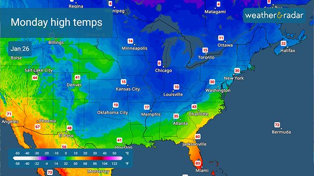
Monday's forecast high temperatures
TemperatureRadar: Monday's forecast high temperatures for the eastern two-thirds.

Record cold temperatures are possible from southwest New Mexico to Kentucky on Monday, and many won't see the thermometer top the freezing mark for days across much of the eastern two-thirds.

Becca Parker
More on the topic
Longest day of the year is here. Summer solstice. . . Sunday, June 21, 2026
Sunday, June 21, 2026

Summer solstice

Longest day of the year is here
Super Typhoon Near the Philippines. Gusts up to 155. . . Tuesday, June 23, 2026
Tuesday, June 23, 2026

Gusts up to 155

Super Typhoon Near the Philippines
High pressure & extreme heat. Why & how does it work?. . . Sunday, July 12, 2026
Sunday, July 12, 2026

Why & how does it work?

High pressure & extreme heat
All weather news
This might also interest you
Multi-Day flood threat for Mid-Atlantic. Stalled front. . . Wednesday, July 22, 2026
Wednesday, July 22, 2026

Stalled front

Multi-Day flood threat for Mid-Atlantic
Temps 15-degrees below average. Big cold front. . . Wednesday, July 22, 2026
Wednesday, July 22, 2026

Big cold front

Temps 15-degrees below average
Lopsided Bertha moves west. Who sees the impacts. . . Thursday, July 23, 2026
Thursday, July 23, 2026

Who sees the impacts

Lopsided Bertha moves west
All articles
Weather & Radar

Weather & Radar is also available on

Google Play StoreApp Store

Company

Contact us Privacy policy Legal info Accessibility statement

Services

Uploader

Socials

instagramfacebookthreadslinkList