Home
Weather New York
WeatherRadar
RainRadar
TemperatureRadar
WindRadar
LightningRadar
Weather News
Editor's Pick
Discover the app
Weather widget
Contact us
Apps
Career
    Home / Weather News /

    Breakfast Brief: East stays stormy, Texas flood threat

09:00 AM
July 23, 2024

Breakfast Brief
East stays stormy, Texas flood threat

Tuesday will be another day of typical summer-time showers and thunderstorm activity across much of the Eastern Contiguous United States. However, some locations will remain dry and very hot.

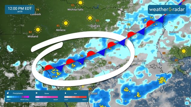
A stalled front stretching from Texas to the Mid-Atlantic will bring scattered showers and thunderstorms to much of the eastern half of the lower 48 today. Stay tuned to the WeatherRadar and remain vigilant, especially if you've had heavy rain recently, as the risk of flash floods is higher due to saturated soils.

Did you know?

On this day in 2011, Chicago set its all-time daily rainfall record with 6.86 inches during the pre-dawn hours of July 23. Even without any other rain that month, it would still rank as one of the city's top ten wettest Julys.

stalled front july 23, 2024

Meanwhile, the West continues to experience intense heat and dry conditions, with temperatures peaking today or tomorrow. By mid-week, the heat wave will shift east into the Northern Plains. Cities like Salt Lake City, Boise, Idaho and Billings, Mont., are expected to approach record-high temperatures on Wednesday and Thursday.

Tropical update:

A low-pressure system south of southern Mexico has a low chance of developing as it moves west-northwest. Similarly, another tropical system south of Baja California is moving northwest with a low chance of development over the next 7 days. Neither system poses a risk of land impacts during this period.

The news we're covering today:

  • Flood threat spreads east across Texas

Did you miss these?

Dallas highway floodedSee the images
Waterspouts spotted in South FloridaSee the images

App news & updates

When heat builds, and a front nears, the atmosphere's natural response is to produce storms. Under the right conditions, these storms can become strong or even damaging. Always stay storm-aware with our automated alert system. Here's how you can turn it on!

Federico Di Catarina
This might also interest you
Be ready for tropical activity. Tips & tools. . . Saturday, August 29, 2026
Track hurricanes with the WeatherRadar
Saturday, August 29, 2026

Tips & tools

Be ready for tropical activity
9 inches of rain, 4 feet of surge. Texas & Louisiana. . . Tuesday, September 1, 2026
Tropical Storm Edouard will bring heavy rains and gusty winds, with flooding possible.
Tuesday, September 1, 2026

Texas & Louisiana

9 inches of rain, 4 feet of surge
Hurricane parade in the Pacific. Karina is very strong. . Weather Videos. Tuesday, September 1, 2026
WindRadar for Friday, showing the three hurricanes – Lowell, Karina and Maria – over the Pacific.
Weather VideosTuesday, September 1, 2026

Karina is very strong

Hurricane parade in the Pacific
All articles
Weather & Radar

Weather & Radar is also available on

Google Play StoreApp Store

Company

Contact us Privacy policy Legal info Accessibility statement

Services

Uploader

Socials

instagramfacebookthreadslinkList