Home
Weather New York
WeatherRadar
RainRadar
TemperatureRadar
WindRadar
LightningRadar
Weather News
Editor's Pick
Discover the app
Weather widget
Contact us
Apps
Career
    Home / Weather News /

    Look up! Those are "Streets Clouds" or undulatus clouds

04:09 PM
January 13, 2025

How do they form?
Look up! Those are "Streets Clouds"

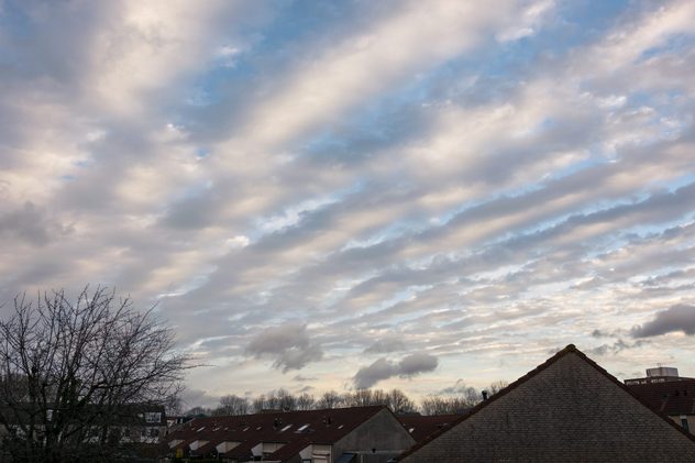
Look up! You might be seeing these beauties in the sky! We certainly see them on our WeatherRadar! What are they called? How do they form?

Street clouds are altocumulus clouds, clouds in the middle levels of the atmosphere. Their technical name is Undulatus Clouds. Yes, because they undulate! They are also known as street clouds because of how they resemble streets.

Undulatus clouds are a sign of fair weather or stable conditions. Clouds form where there is ascending air and clear spaces where there is descending air. The clouds that form orient themselves with the mean winds. Check out the WindRadar and confirm for yourself!

If you spot these clouds or any other cool ones, send them over! We would love to feature them and explain the process of how they form. Send your weather pictures here.

Irene Sans
More on the topic
Europe: Warmest June on record. Warm waters too. . . Friday, July 10, 2026
The record-breaking heatwave in June has made climate history in Western Europe.
Friday, July 10, 2026

Warm waters too

Europe: Warmest June on record
Super Typhoon Bavi threatens Taiwan. 155 mph winds. . Weather Videos. Wednesday, July 8, 2026
The image shows an intense tropical cyclone over the western Pacific, east of Taiwan and the Philippines. The centre of the system is depicted as a light purple and white vortex with a clearly visible eye, surrounded by a ring of red and orange areas indicating the strongest wind speeds. A white arrow marks the typhoon’s predicted track towards the north-west, in the direction of Taiwan. To the west of the storm lie the Philippines, with the cities of Manila and Cebu; to the north of these lies Taiwan, with Taipei. Further west, the Chinese coast, including Hong Kong, and parts of Vietnam can be seen. The coloured wind map shows predominantly green areas outside the storm’s core, indicating significantly weaker winds. White streamlines illustrate the typhoon’s anti-clockwise circulation in the Northern Hemisphere. The highest wind speeds are concentrated around the eye of the cyclone.
Weather VideosWednesday, July 8, 2026

155 mph winds

Super Typhoon Bavi threatens Taiwan
High pressure & extreme heat. Why & how does it work?. . . Sunday, July 12, 2026
Sunday, July 12, 2026

Why & how does it work?

High pressure & extreme heat
All weather news
This might also interest you
Poor air quality to span 1.2K+ miles. Canadian wildfires. . . Wednesday, July 15, 2026
Wednesday, July 15, 2026

Canadian wildfires

Poor air quality to span 1.2K+ miles
How does a hurricane form?. Hurricane preparedness. . . Sunday, July 19, 2026
hurricane maria
Sunday, July 19, 2026

Hurricane preparedness

How does a hurricane form?
Year's worth of rainfall piling up. Southwest Texas. . . Thursday, July 16, 2026
Extreme weather alerts active in Southwest Texas.
Thursday, July 16, 2026

Southwest Texas

Year's worth of rainfall piling up
All articles
Weather & Radar

Weather & Radar is also available on

Google Play StoreApp Store

Company

Contact us Privacy policy Legal info Accessibility statement

Services

Uploader

Socials

instagramfacebookthreadslinkList