Home
Weather New York
WeatherRadar
RainRadar
TemperatureRadar
WindRadar
LightningRadar
Weather News
Editor's Pick
Discover the app
Weather widget
Contact us
Apps
Career
    Home / Weather News /

    Breakfast Brief: Northeast severe storm risk increases

09:00 AM
June 26, 2024

Breakfast Brief
Northeast severe storm risk increases

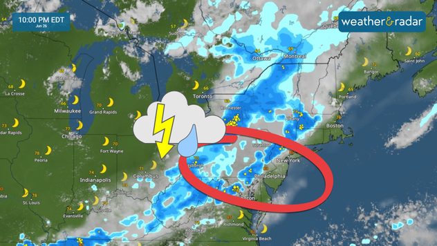
An east-moving front will increase shower and thunderstorm activity across the Northeast and Mid-Atlantic today. The I-95 corridor is under the biggest threat of severe thunderstorms.

Did you know?

On this day in 1980, severe thunderstorms caused extensive damage in Genesee and Orleans counties in New York. These storms led to power outages, street flooding, crop damage, and unconfirmed tornadoes.

Showers and thunderstorms will continue moving east across much of the eastern U.S. as a cold front passes through the region. Some storms could be strong to severe, with the highest risk expected from Pittsburgh to the I-95 corridor between Washington, D.C., and New York. Storms are forecast to reach the eastern seaboard by late evening.

Monsoon showers and thunderstorms that affected the Desert Southwest and Four Corners region this week will shift eastward. The focus will be on eastern Arizona, New Mexico, and Colorado. Some storms may become strong and produce isolated flash flooding.

thunderstomrs june 26

Tropical Update

A tropical wave producing showers and thunderstorms will track across the Caribbean this week. Conditions remain marginally conducive for this system to strengthen as it reaches the western Caribbean or southern Gulf of Mexico by this weekend.

The news we're covering today:

  • Increasing risk for severe thunderstorms across the Eastern Seaboard

Did you miss these?

Deep Saharan dust, tropical waveread more
Recent LightningRadar upgradesread more

App news:

Did you know you can receive notifications for incoming tropical systems? Our storm alert feature keeps you informed about dangerous winds, heavy rain, or storm surge in your area. Simply turn on your alerts to stay updated. Find out how here.

Federico Di Catarina
This might also interest you
Flooding rains shift north along I-95. 5 inches more. . . Wednesday, July 29, 2026
Extreme weather alerts are active as heavy rain could cause flooding issues.
Wednesday, July 29, 2026

5 inches more

Flooding rains shift north along I-95
Rip currents & safety tips. As more head to the coast. . . Saturday, July 25, 2026
rip current
Saturday, July 25, 2026

As more head to the coast

Rip currents & safety tips
Dry vegetation, low humidity and winds. The perfect fire recipe. . . Sunday, July 26, 2026
Sunday, July 26, 2026

The perfect fire recipe

Dry vegetation, low humidity and winds
All articles
Weather & Radar

Weather & Radar is also available on

Google Play StoreApp Store

Company

Contact us Privacy policy Legal info Accessibility statement

Services

Uploader

Socials

instagramfacebookthreadslinkList