Home
Weather New York
WeatherRadar
RainRadar
TemperatureRadar
WindRadar
LightningRadar
Weather News
Editor's Pick
Discover the app
Weather widget
Contact us
Apps
Career
    Home / Weather News /

    Here's Why Those Gloomy California Coast Days Are Both Fascinating and Crucial

07:33 PM
May 16, 2024

Science behind the gloom
Understanding May Gray on the West Coast

may-gray

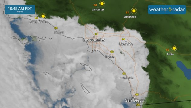
If you live on the West Coast, you're probably well aware of those stubborn summer clouds known as 'May Gray.' While they might seem annoying, their formation process is fascinating, and they play a crucial role in maintaining the region's unique biome.

'May gray' refers to the persistent gray skies that hover over the southern California coast during the month of May. This phenomenon occurs mostly during the late-spring to early-summer months, typically from the overnight to morning hours. Under the right conditions, overcast skies can extend into the afternoon or even persist for several days.

Did you know?

Did you know? 'May Gray' and 'June Gloom' describe the overcast skies in Southern California's late spring and early summer, with other fun names like 'No-Sky July' and 'Fogust' extending the phenomenon into July and August.

Cloudy summer mornings are crucial because they significantly impact the climate of Southern California's coastal regions compared to areas just a few dozen miles inland. The cloudy skies trap marine moisture at the surface, fostering a denser and more diverse biome.

How does it form?

'May gray' results from a combination of local climate and geography. On a typical 'May gray' day, a low-pressure system generates steady southeast or northeast winds that carry a dense, moist marine layer, fueled by cold ocean temperatures, to the California coast.

As the marine layer approaches land, it slows and turns east toward the coast. This cool, moist ocean flow leads to the formation of low clouds as temperatures drop in the evening. By early morning, thick clouds have moved several miles inland. If there is enough cooling and upslope lift, light to moderate drizzle may occur. The clouds often remain through the morning and dissipate as temperatures rise in the afternoon.

Occasionally, persistent 'May gray' periods occur when clouds become trapped beneath an inversion layer of warmer air. This inversion acts like a lid, allowing overcast skies to last for days.

Federico Di Catarina
More on the topic
Rip currents & safety tips. As more head to the coast. . . Saturday, July 25, 2026
rip current
Saturday, July 25, 2026

As more head to the coast

Rip currents & safety tips
Meteorological summer is here!. Bye, spring!. . . Monday, June 1, 2026
Monday, June 1, 2026

Bye, spring!

Meteorological summer is here!
Europe: Warmest June on record. Warm waters too. . . Friday, July 10, 2026
The record-breaking heatwave in June has made climate history in Western Europe.
Friday, July 10, 2026

Warm waters too

Europe: Warmest June on record
All weather news
This might also interest you
Dry vegetation, low humidity and winds. The perfect fire recipe. . . Sunday, July 26, 2026
Sunday, July 26, 2026

The perfect fire recipe

Dry vegetation, low humidity and winds
Multi-day rain event ends soon. Southeast U.S.. . . Friday, July 24, 2026
Friday, July 24, 2026

Southeast U.S.

Multi-day rain event ends soon
Southwest heat disrupts daily flow. Closures & delays. . . Monday, July 27, 2026
Monday, July 27, 2026

Closures & delays

Southwest heat disrupts daily flow
All articles
Weather & Radar

Weather & Radar is also available on

Google Play StoreApp Store

Company

Contact us Privacy policy Legal info Accessibility statement

Services

Uploader

Socials

instagramfacebookthreadslinkList