Home
Weather New York
WeatherRadar
RainRadar
TemperatureRadar
WindRadar
LightningRadar
Weather News
Editor's Pick
Discover the app
Weather widget
Contact us
Apps
Career
    Home / Weather News /

    5 inches more - Flooding rains shift north along I-95

05:23 PM
July 29, 2026

5 inches more
Flooding rains shift north along I-95

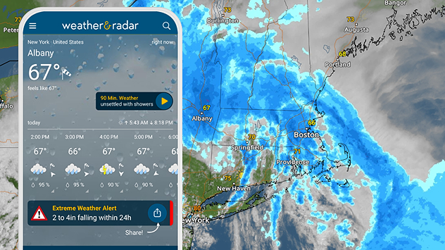
Between 3.6 and 9.4 inches of flooding rain have fallen in the Mid-Atlantic and Northeast since Tuesday, thanks to a juicy storm system. An additional five inches could fall on Wednesday as the wet system shifts slightly northward.

A potent low-pressure system can be seen churning in the Northeast on the WeatherRadar, keeping many under umbrellas. As of Wednesday morning, 9.4 inches of rain have piled up in eastern New York, just southeast of Albany. More rain is expected throughout the day, posing another flood risk.

Extreme weather alerts are active as heavy rain could cause flooding issues.

Although flash flooding could occur from New York City to Malone, N.Y., through Waterville, Maine, a focus area for flash flooding includes places like Albany and Kingston, N.Y., Pittsfield to Marlborough, Mass., Hartford and Meriden, Conn., and southern Vermont.

As much as 5 inches could be added to the already soggy ground, with locally higher amounts. Downpours could drop 1 to 2 inches per hour at times. Weather & Radar's extreme weather alerts are active.

Share your weather viewsread more
Becca Parker
More on the topic
Europe: Warmest June on record. Warm waters too. . . Friday, July 10, 2026
The record-breaking heatwave in June has made climate history in Western Europe.
Friday, July 10, 2026

Warm waters too

Europe: Warmest June on record
Super Typhoon Bavi threatens Taiwan. 155 mph winds. . Weather Videos. Wednesday, July 8, 2026
The image shows an intense tropical cyclone over the western Pacific, east of Taiwan and the Philippines. The centre of the system is depicted as a light purple and white vortex with a clearly visible eye, surrounded by a ring of red and orange areas indicating the strongest wind speeds. A white arrow marks the typhoon’s predicted track towards the north-west, in the direction of Taiwan. To the west of the storm lie the Philippines, with the cities of Manila and Cebu; to the north of these lies Taiwan, with Taipei. Further west, the Chinese coast, including Hong Kong, and parts of Vietnam can be seen. The coloured wind map shows predominantly green areas outside the storm’s core, indicating significantly weaker winds. White streamlines illustrate the typhoon’s anti-clockwise circulation in the Northern Hemisphere. The highest wind speeds are concentrated around the eye of the cyclone.
Weather VideosWednesday, July 8, 2026

155 mph winds

Super Typhoon Bavi threatens Taiwan
Rip currents & safety tips. As more head to the coast. . . Saturday, July 25, 2026
rip current
Saturday, July 25, 2026

As more head to the coast

Rip currents & safety tips
All weather news
This might also interest you
Southwest heat disrupts daily flow. Closures & delays. . . Monday, July 27, 2026
Monday, July 27, 2026

Closures & delays

Southwest heat disrupts daily flow
Multi-day rain event ends soon. Southeast U.S.. . . Friday, July 24, 2026
Friday, July 24, 2026

Southeast U.S.

Multi-day rain event ends soon
Up to four feet of storm surge. Gulf Coast soaker. . . Tuesday, July 21, 2026
Tropical storm alerts are active in the app as Bertha continues to churn in the northern Gulf.
Tuesday, July 21, 2026

Gulf Coast soaker

Up to four feet of storm surge
All articles
Weather & Radar

Weather & Radar is also available on

Google Play StoreApp Store

Company

Contact us Privacy policy Legal info Accessibility statement

Services

Uploader

Socials

instagramfacebookthreadslinkList