Home
Weather New York
WeatherRadar
RainRadar
TemperatureRadar
WindRadar
LightningRadar
Weather News
Editor's Pick
Discover the app
Weather widget
Contact us
Apps
Career
    Home / Weather News /

    Southeast U.S. - Multi-day rain event ends soon

05:26 PM
July 24, 2026

Southeast U.S.
Multi-day rain event ends soon

Heavy rains have been falling across the Carolinas and Southeast since early in the week, but relief is not far. Flooding impacts are expected through Saturday.

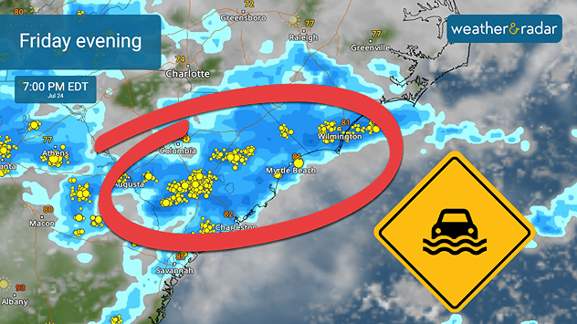
Although a flash-flood risk is active from the mid-Mississippi Valley through the Carolinas, a focus area includes places like Charleston, Columbia and Myrtle Beach, S.C., as well as Wilmington, N.C. Rain rates of 2 to 3 inches per hour are expected on Friday, and the WeatherRadar shows plenty of activity lasting through Saturday.

Flash flooding is possible Friday evening along the Southeast Coast into central South Carolina.

Heavy rain alerts are active for the focus area of the Southeast Coast. Make sure you're receiving the most up-to-date notifications on your Weather & Radar app.

Activate your weather alertsread more
Becca Parker
More on the topic
Record-breaking heatwave in Europe. Hotter than most of U.S.. . . Thursday, June 25, 2026
Thursday, June 25, 2026

Hotter than most of U.S.

Record-breaking heatwave in Europe
Rip currents & safety tips. As more head to the coast. . . Saturday, July 25, 2026
rip current
Saturday, July 25, 2026

As more head to the coast

Rip currents & safety tips
Europe: Warmest June on record. Warm waters too. . . Friday, July 10, 2026
The record-breaking heatwave in June has made climate history in Western Europe.
Friday, July 10, 2026

Warm waters too

Europe: Warmest June on record
All weather news
This might also interest you
Lopsided Bertha moves west. Who sees the impacts. . . Thursday, July 23, 2026
Thursday, July 23, 2026

Who sees the impacts

Lopsided Bertha moves west
Multi-Day flood threat for Mid-Atlantic. Stalled front. . . Wednesday, July 22, 2026
Wednesday, July 22, 2026

Stalled front

Multi-Day flood threat for Mid-Atlantic
Up to four feet of storm surge. Gulf Coast soaker. . . Tuesday, July 21, 2026
Tropical storm alerts are active in the app as Bertha continues to churn in the northern Gulf.
Tuesday, July 21, 2026

Gulf Coast soaker

Up to four feet of storm surge
All articles
Weather & Radar

Weather & Radar is also available on

Google Play StoreApp Store

Company

Contact us Privacy policy Legal info Accessibility statement

Services

Uploader

Socials

instagramfacebookthreadslinkList