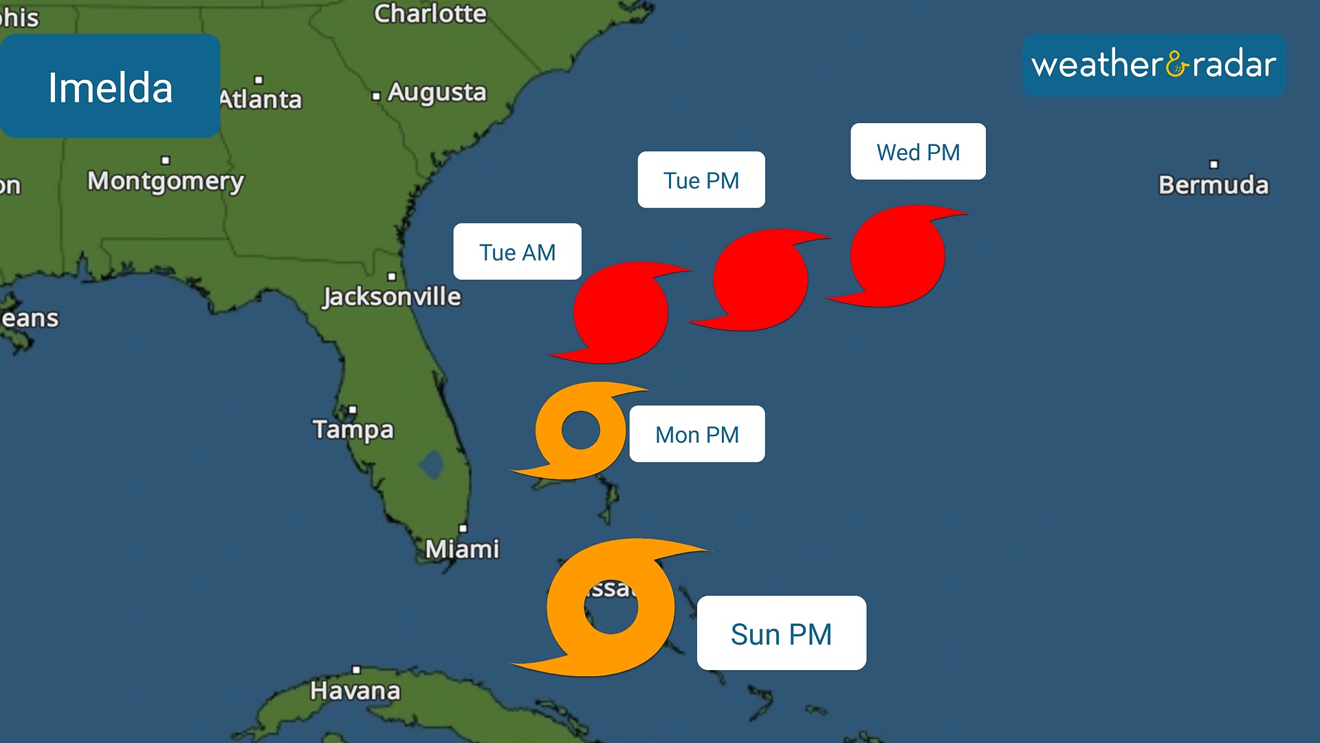
Home / Weather News /

Tropical Storm Imelda, turn in track

08:34 PM
September 28, 2025

Indirect impacts
Tropical Storm Imelda and a turn in track

Sunday afternoon began with the disturbance being upgraded to Tropical Storm Imelda. The good news is that the track has shifted slightly eastward, sparing the U.S. from a direct hit.

Imelda remains very disorganized but is forecast to continue strengthening as it enters the Gulf Stream. This warm current flows from south to north along the southeastern coast of the country. By Tuesday, Imelda could become a hurricane. Imelda's track remains between 200 and 300 miles east of Florida's east coast. This is a safe distance to avoid direct hits.

Track issued on Sunday afternoon.

Of course, the sea is going to be very dangerous, even near the coast. Waves could reach 10 to 12 feet from South Florida to the northeast of the state, but higher waves and a greater risk of beach erosion are expected along the central east coast, particularly along the Space Coast. Another risk that Imelda will bring to the nation's southeastern coast, aside from high waves and very rough seas, is the risk of rip currents that will continue from Florida to the Carolinas during the first half of this coming work week.

For the Carolinas, Imelda's front and moisture will bring some rain, but the trend, as in Florida, is drying out. The marine area will be highly hazardous, characterized by high waves, rough seas, and a significant risk of rip currents. Please avoid the ocean and any beach activities.

Check your coastal conditionsread more

Why the turn east?

There are many factors causing Imelda to turn east. The first is a front that keeps Florida free from direct hazards, and this same front also prevents it from continuing its northward path. Hurricane Humberto is also helping to pull Imelda along, trying to absorb it. Florida will continue to experience a trend of less rain for much of the Peninsula, except for some areas on the east coast, where showers and breezes will be present.

Irene Sans
More on the topic
First frosts can begin in September as autumn temps move in.
Sunday, September 21, 2025

Meteorological autumn

The average first frosts in the U.S.
Wednesday, September 10, 2025

Unusually quiet

Why is it so calm in the Atlantic?
Warm 2025 autumn equinox
Monday, September 22, 2025

Autumn Equinox

Fall is officially here!
All weather news
This might also interest you
Thursday, September 25, 2025

Fujiwhara effect

The dancing storms, that sometimes merge
Thursday, September 25, 2025

Daily briefing

Autumn soaker heads East
Track hurricanes with the WeatherRadar
Sunday, September 28, 2025

Tips & tools

Be ready for tropical activity
All articles
Weather & Radar

www.weatherandradar.com

instagramfacebookthreadsContact uslinkList
Privacy policy | Legal info | Accessibility statement