Home
Weather New York
WeatherRadar
RainRadar
TemperatureRadar
WindRadar
LightningRadar
Weather News
Editor's Pick
Discover the app
Weather widget
Contact us
Apps
Career
    Home / Weather News /

    Daily briefing: Autumn soaker heads East

09:00 AM
September 25, 2025

Daily briefing
Autumn soaker heads East

Autumn rain and few thunderstorms will be the big story from the central Gulf Coast into the Northeast today. This, and our tropical update, are available at 5 a.m. ET in our daily briefing.

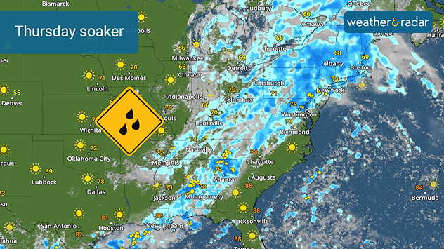
The same autumn storm system that has been slowly moving across the Plains and Midwest all week will continue its slow slog eastward today. The WeatherRadar shows heavy rain with embedded thunderstorms from the central Gulf Coast northeastward across the interior Southeast, Mid-Atlantic and the Northeast.

Heavy rain will soak large stretches of the South and Northeast today.

This will provide much needed drought relief along the I-95 corridor from Atlanta to Boston, including Washington, Baltimore, Philadelphia and New York City.

Outside of spotty thunderstorms across the Southwest into the Great Basin, the rest of the U.S. from the Plains to the Pacific Coast will have a sunny and pleasant Thursday.

Autumn remains elusive across the U.S., with highs today surpassing 70 degrees everywhere. The TemperatureRadar shows the Southwest, southern Rockies, Texas and the Gulf Coast into Florida and the coastal Southwest will be hot with highs in the upper 80s and low 90s. Phoenix and the low desert of the Southwest will top out around 105 degrees.

Tropical Update

Hurricane Gabrielle is turning to the east and will gradually weaken as it moves across the central Atlantic. It could threaten the eastern Atlantic Azores this weekend.

Tropical Storm Humberto formed late Wednesday afternoon and will move to the northwest over the wide-open Atlantic for the next several days. It could become the season's next hurricane later this weekend far from land.

A third system will need to be watched over the next several days. This one could become a tropical depressions later this week even as it brings heavy rain to the Greater Antilles over the next several days.

App News

Although it has been quiet recently, the Atlantic Hurricane Season is trying to perk up heading into the season's second half. Here is more information to know this hurricane season.

James West
More on the topic
Super Typhoon Bavi threatens Taiwan. 155 mph winds. . Weather Videos. Wednesday, July 8, 2026
The image shows an intense tropical cyclone over the western Pacific, east of Taiwan and the Philippines. The centre of the system is depicted as a light purple and white vortex with a clearly visible eye, surrounded by a ring of red and orange areas indicating the strongest wind speeds. A white arrow marks the typhoon’s predicted track towards the north-west, in the direction of Taiwan. To the west of the storm lie the Philippines, with the cities of Manila and Cebu; to the north of these lies Taiwan, with Taipei. Further west, the Chinese coast, including Hong Kong, and parts of Vietnam can be seen. The coloured wind map shows predominantly green areas outside the storm’s core, indicating significantly weaker winds. White streamlines illustrate the typhoon’s anti-clockwise circulation in the Northern Hemisphere. The highest wind speeds are concentrated around the eye of the cyclone.
Weather VideosWednesday, July 8, 2026

155 mph winds

Super Typhoon Bavi threatens Taiwan
Rip currents & safety tips. As more head to the coast. . . Sunday, July 5, 2026
rip current
Sunday, July 5, 2026

As more head to the coast

Rip currents & safety tips
High pressure & extreme heat. Why & how does it work?. . . Sunday, June 28, 2026
Sunday, June 28, 2026

Why & how does it work?

High pressure & extreme heat
All weather news
This might also interest you
Slow-moving storms and heavy rain. What to look for. . . Monday, July 6, 2026
Monday, July 6, 2026

What to look for

Slow-moving storms and heavy rain
Saharan dust to reach Florida. Dry period expected. . . Tuesday, July 7, 2026
Saharan dust seen on the satllite image (right) moving westward toward Florida. Air quality impacts are expected.
Tuesday, July 7, 2026

Dry period expected

Saharan dust to reach Florida
Turning hot this weekend. Brutal temps across West. . . Friday, July 10, 2026
Saturday & Sunday's highs
Friday, July 10, 2026

Brutal temps across West

Turning hot this weekend
All articles
Weather & Radar

Weather & Radar is also available on

Google Play StoreApp Store

Company

Contact us Privacy policy Legal info Accessibility statement

Services

Uploader

Socials

instagramfacebookthreadslinkList