Home
Weather New York
WeatherRadar
RainRadar
TemperatureRadar
WindRadar
LightningRadar
Weather News
Editor's Pick
Discover the app
Weather widget
Contact us
Apps
Career
    Home / Weather News /

    7 inches and counting - SW Texas quadruples its normal July rain

01:25 PM
July 14, 2026

7 inches and counting
SW Texas quadruples its normal July rain

Southwest Texas has received more than four times the amount of rain that normally falls in July in the last day due to a stationary front. More to come.

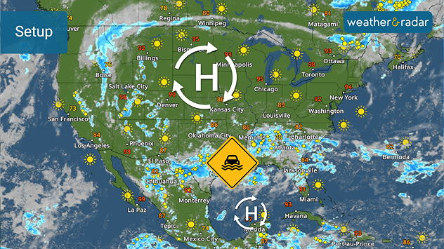
A stationary front, wedged between two high-pressure systems, continues to bring several inches of rain from Texas to the Tennessee Valley and Southeast. While one high pressure is bringing 100-degree heat to the northern Plains and Upper Midwest, the other is churning in the southern Gulf. The southern U.S. has been caught in a soggy pattern in the middle of these two circulations.

The stationary front bringing flooding rains is wedged between two high-pressure systems.

Normally, southwest Texas gets a little over two inches of rain in July, and during this event, many spots have reached between 7 and 9 inches with Hondo, Texas, getting around 14 inches - an entire summer's worth of rainfall.

The WeatherRadar shows heavy, slow-moving storms continuing and not letting up until the end of the week, especially for Texas. Extreme weather alerts are active.

Becca Parker
More on the topic
High pressure & extreme heat. Why & how does it work?. . . Sunday, July 12, 2026
Sunday, July 12, 2026

Why & how does it work?

High pressure & extreme heat
Rip currents & safety tips. As more head to the coast. . . Saturday, July 25, 2026
rip current
Saturday, July 25, 2026

As more head to the coast

Rip currents & safety tips
Meteorological summer is here!. Bye, spring!. . . Monday, June 1, 2026
Monday, June 1, 2026

Bye, spring!

Meteorological summer is here!
All weather news
This might also interest you
Three common misperceptions. Hurricane season. . . Sunday, August 2, 2026
Hurricane Ian (2022) satellite imagery before SWFL landfall.
Sunday, August 2, 2026

Hurricane season

Three common misperceptions
The meeting of the wet masses. A Florida story. . . Wednesday, August 5, 2026
Two air masses conerge to produce storms & heavy downpours across the Florida Peninsula today.
Wednesday, August 5, 2026

A Florida story

The meeting of the wet masses
Heat not felt in 80+ years. Pacific Northwest. . . Tuesday, August 4, 2026
Records as old as 81 and even 124 years could fall this first week of August in the Pacific Northwest as temperatures rise to the 90s & triple digits due to a new heatwave.
Tuesday, August 4, 2026

Pacific Northwest

Heat not felt in 80+ years
All articles
Weather & Radar

Weather & Radar is also available on

Google Play StoreApp Store

Company

Contact us Privacy policy Legal info Accessibility statement

Services

Uploader

Socials

instagramfacebookthreadslinkList