Home
Weather New York
WeatherRadar
RainRadar
TemperatureRadar
WindRadar
LightningRadar
Weather News
Editor's Pick
Discover the app
Weather widget
Contact us
Apps
Career
    Home / Weather News /

    A Florida story - The meeting of the wet masses

07:17 PM
August 5, 2026

A Florida story
The meeting of the wet masses

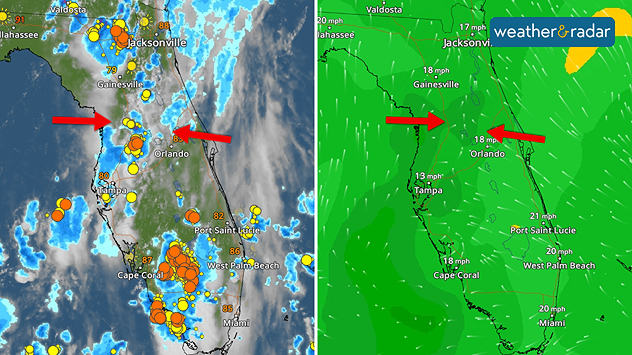
A convergence of two wet air masses is triggering wet weather across Florida today.

Floridians are no strangers to muggy days, but sometimes it's tough to see just how this forecast comes about. The WindRadar is demonstrating the meeting of two wet air masses bringing about today's downpours.

The WeatherRadar shows wet and stormy weather moving across the Peninsula today, but the WindRadar is showing more to this story. Saturated winds moving out of the western Atlantic and the eastern Gulf are converging, creating a potent environment for afternoon downpours.

Many downpours will occur just as commuters hit the road. The Weather & Radar app provides real-time alerts to notify you when heavy rainfall or strong thunderstorms are nearby.

Becca Parker
More on the topic
Record-breaking heatwave in Europe. Hotter than most of U.S.. . . Thursday, June 25, 2026
Thursday, June 25, 2026

Hotter than most of U.S.

Record-breaking heatwave in Europe
Super Typhoon Bavi threatens Taiwan. 155 mph winds. . Weather Videos. Wednesday, July 8, 2026
The image shows an intense tropical cyclone over the western Pacific, east of Taiwan and the Philippines. The centre of the system is depicted as a light purple and white vortex with a clearly visible eye, surrounded by a ring of red and orange areas indicating the strongest wind speeds. A white arrow marks the typhoon’s predicted track towards the north-west, in the direction of Taiwan. To the west of the storm lie the Philippines, with the cities of Manila and Cebu; to the north of these lies Taiwan, with Taipei. Further west, the Chinese coast, including Hong Kong, and parts of Vietnam can be seen. The coloured wind map shows predominantly green areas outside the storm’s core, indicating significantly weaker winds. White streamlines illustrate the typhoon’s anti-clockwise circulation in the Northern Hemisphere. The highest wind speeds are concentrated around the eye of the cyclone.
Weather VideosWednesday, July 8, 2026

155 mph winds

Super Typhoon Bavi threatens Taiwan
Super Typhoon Near the Philippines. Gusts up to 155. . . Tuesday, June 23, 2026
Tuesday, June 23, 2026

Gusts up to 155

Super Typhoon Near the Philippines
All weather news
This might also interest you
August starts blazing hot. Weekend preview. . . Thursday, July 30, 2026
Triple digit Saturday for the Mountain West.
Thursday, July 30, 2026

Weekend preview

August starts blazing hot
Heat not felt in 80+ years. Pacific Northwest. . . Tuesday, August 4, 2026
Records as old as 81 and even 124 years could fall this first week of August in the Pacific Northwest as temperatures rise to the 90s & triple digits due to a new heatwave.
Tuesday, August 4, 2026

Pacific Northwest

Heat not felt in 80+ years
Flooding rains shift north along I-95. 5 inches more. . . Wednesday, July 29, 2026
Extreme weather alerts are active as heavy rain could cause flooding issues.
Wednesday, July 29, 2026

5 inches more

Flooding rains shift north along I-95
All articles
Weather & Radar

Weather & Radar is also available on

Google Play StoreApp Store

Company

Contact us Privacy policy Legal info Accessibility statement

Services

Uploader

Socials

instagramfacebookthreadslinkList