Home
Weather New York
WeatherRadar
RainRadar
TemperatureRadar
WindRadar
LightningRadar
Weather News
Editor's Pick
Discover the app
Weather widget
Contact us
Apps
Career
    Home / Weather News /

    A recap: 450 severe reports, almost 6" of rain

09:29 PM
January 10, 2024

A winter storm recap
450 severe reports, almost 6" of rain

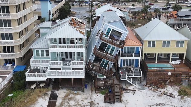
Panama City Beach, Fla., tornado damage.

More than 450 severe weather reports, almost half a foot of rainfall, nearly 2 feet of snow, and wind gusts reaching above 90 mph were all a part of the winter storm that hit much of the eastern two-thirds of the U.S., since late Sunday through Wednesday morning.

This massive winter storm brought blizzard conditions, tornadoes, power outages, flooding, and school closures as it moved across the U.S. Many vehicles were abandoned in Kansas due to the blizzard conditions.

Privacy policy

On the severe weather side, tornadoes hit the Gulf Coast through the Carolinas Monday into Tuesday. Surveys are taking place today to recap the damage and classify the tornado intensity for each area impacted. Structures were flattened or knocked over, power was knocked out, and at least four people lost their lives due to the severe storms and tornadoes.

Many of the storms happened overnight, adding the extra threat of nocturnal storms. Some neighborhoods were lucky enough to miss the tornadoes, but still got the stunning view.

Florida won the tornado warning contest with 46 of the 110 total occurring in that state alone as a large and strong squall line blasted through.

Florida tornadoesread more

Wind wise, high wind warnings and wind advisories blanketed the map noting most areas getting 40 to 50 mph wind gusts with higher ones in the Appalachians reaching above 60 mph. In the tornado-hit area of Santa Rosa Beach, Fla., one station recorded a 106 mph wind gust.

Hundreds of thousands are still without power as the exiting storm is still causing gusty winds. Power outages extend up from North Carolina through Maine and include Michigan too. Wind advisories and high wind warnings are still active today in the Ohio Valley through the Northeast.

Wilton, Conn., and Montgomery, Ala., recorded more than 5 inches of rainfall in the event. Excessive rainfall risks were posted warning the area of the potentially flooding rains days before the first drop fell.

Flood warnings and advisories are still active even after the rain has moved out for many across the East due to rising rivers and streams, not only due to the heavy rainfall averaging about 1-3 inches, but also due to the melting snow across the Appalachians adding to the moisture.

The next big storm is already on the coattails of this last one and will cause more wintry and severe weather issues starting Thursday.

Learn more about the severe weather side with the latest update from Meteorologist Mary Mays.

Becca Parker
More on the topic
Hurricane Polo remains dangerous. Active Pacific. . . Thursday, September 24, 2026
Thursday, September 24, 2026

Active Pacific

Hurricane Polo remains dangerous
10 facts about fog. Low clouds. . . Sunday, September 27, 2026
Fog impacting the Appalachian Mountains.
Sunday, September 27, 2026

Low clouds

10 facts about fog
Record ocean heat halting hurricanes. Strong El Niño influence. . . Sunday, September 13, 2026
A weather map shows a calm Atlantic Ocean with no hurricanes, alongside a picture of the sea.
Sunday, September 13, 2026

Strong El Niño influence

Record ocean heat halting hurricanes
All weather news
This might also interest you
Soggy end to the weekend for some. Remnants of Isaias. . . Sunday, October 11, 2026
While Isaias may have made landfall near Destin, Fla., Friday night, the hurricane's remnants will bring a soggy end to the weekend hundreds of miles away from the point of landfall.
Sunday, October 11, 2026

Remnants of Isaias

Soggy end to the weekend for some
Tropical moisture meets cold air. First snow of the season. . . Saturday, October 10, 2026
Saturday, October 10, 2026

First snow of the season

Tropical moisture meets cold air
Isaias post-landfall impacts. Southeast soaker. . . Saturday, October 10, 2026
Southeast impacts of Isaias
Saturday, October 10, 2026

Southeast soaker

Isaias post-landfall impacts
All articles
Weather & Radar

Weather & Radar is also available on

Google Play StoreApp Store

Company

Contact us Privacy policy Legal info Accessibility statement

Services

Uploader

Socials

instagramfacebookthreadslinkList