Home
Weather New York
WeatherRadar
RainRadar
TemperatureRadar
WindRadar
LightningRadar
Weather News
Editor's Pick
Discover the app
Weather widget
Contact us
Apps
Career
    Home / Weather News /

    More severe weather for the South on the way to close out the week

04:37 PM
January 10, 2024

Thursday and Friday
More severe weather for the South

Another powerful cross-country storm is set to bring more rounds of heavy snow and severe weather as we head into the end of this week. Severe weather is possible in many areas already hard-hit by storms earlier this week.

The storm system that brought severe storms and possible tornadoes to the South this week is moving out, but another powerful winter storm is right on its heels. Many of the same areas that saw severe storms in the first half of this week will see the potential for more severe weather on Thursday and Friday.

Tornadoes ravage Florida communitiesread more

Our next cross-country storm is currently brewing in the Northwest, where the WeatherRadar shows heavy snow in the higher elevations. As this system moves east into Thursday, snow spreads across the Plains, and storms fire up across the south Thursday evening.

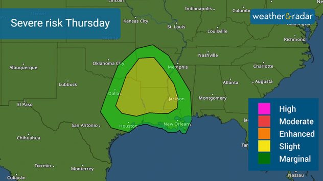
Thursday's severe risk

The Storm Prediction Center has issued a slight risk, a level two out of five of severe storms, over parts of eastern Texas, southeastern Oklahoma, Louisiana, Arkansas, and western Mississippi. Severe hail, damaging winds, and tornadoes will be possible Thursday evening into early Friday morning in Tyler, Texas, Shreveport, La., Little Rock, Ark., and Jackson, Miss.

The severe weather threat continues into Friday, with the threat covering a significant portion of the Southeast. An enhanced risk of severe storms, a level three out of five, extends across portions of Alabama, Georgia, and into the Carolinas. A slight risk extends from eastern Louisiana into southern Virginia.

High winds and a few strong tornadoes will be possible across the Southeast on Friday. Cities including Montgomery, Ala., Atlanta, and Columbia, S.C. need to be especially alert. More than 9 million people are under the enhanced risk Friday, with an additional 19 million under a slight risk.

How to turn on your alertsread more

This is a system to take seriously. Review your severe weather plan now and turn on your Weather & Radar app alerts.

More on the topic
Waterspouts possible, what are they?. They can be dangerous. . . Saturday, July 11, 2026
Waterspouts weatherradar.
Saturday, July 11, 2026

They can be dangerous

Waterspouts possible, what are they?
Meteorological summer is here!. Bye, spring!. . . Monday, June 1, 2026
Monday, June 1, 2026

Bye, spring!

Meteorological summer is here!
How does fog form?. Multiple ways. . . Saturday, July 11, 2026
Saturday, July 11, 2026

Multiple ways

How does fog form?
All weather news
This might also interest you
Desert Southwest heat for the Dakotas. 1,000-mile difference. . . Monday, July 13, 2026
Monday, July 13, 2026

1,000-mile difference

Desert Southwest heat for the Dakotas
Saharan dust to reach Florida. Dry period expected. . . Tuesday, July 7, 2026
Saharan dust seen on the satllite image (right) moving westward toward Florida. Air quality impacts are expected.
Tuesday, July 7, 2026

Dry period expected

Saharan dust to reach Florida
100 miles, 30-degree difference. Southern California. . . Thursday, July 9, 2026
Thursday, July 9, 2026

Southern California

100 miles, 30-degree difference
All articles
Weather & Radar

Weather & Radar is also available on

Google Play StoreApp Store

Company

Contact us Privacy policy Legal info Accessibility statement

Services

Uploader

Socials

instagramfacebookthreadslinkList