Home
Weather New York
WeatherRadar
RainRadar
TemperatureRadar
WindRadar
LightningRadar
Weather News
Editor's Pick
Discover the app
Weather widget
Contact us
Apps
Career
    Home / Editor's Pick /

    Active Central Plains: Multi-day with severe storms

03:35 PM
May 20, 2024

Active Central Plains
Multi-day with severe storms

The weekend ended with a few tornados ripping through Oklahoma, and the week started with more rounds of severe storms over parts of the Central Plains. Here’s the forecast.

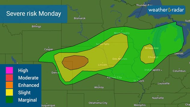
An upper-level low pressure over the western U.S. will move east today and inject instability across the Central Plains. This time, the bullseye is centered across northeastern Colorado, extending to southern Minnesota, including much of Nebraska and Iowa. Over 16 million people are under a slight risk of severe storms and over 200,000 people are at a higher, level 3 of 5, enhanced risk of severe storms. This risk includes Kearney, Neb., North Platte, Neb., Sterling, Colo., and Lexington Neb. These cities and surroundings could experience several significant tornadoes, damaging winds of at least 75 mph, and large hail.

Monday's severe risk will develop mainly in the afternoon and evening hours. Have several ways of receiving weather alerts.

Chicago also needs to be aware that some storms could rip through town. The atmosphere is primed with plenty of moisture and the day’s heating will aid thunderstorms to develop which can produce 60 mph damaging winds and large hail. Flooding could also be possible in some isolated spots. The main threat of severe weather will happen between noon and 7 p.m. It is important to highlight and preview the risk for severe storms and Chicago could have a higher risk for more numerous severe storms on Tuesday. Tuesday’s tornadoes and 70 mph damaging winds will be more likely in the evening, after 6 p.m.

Extensive risk: Tuesday’s severe weather

We should write a preview of what will likely happen on Tuesday in the Central Plains and Midwest. With more moisture and heat available in the atmosphere on Tuesday, the chance for severe storms expands to a much larger section of the Central Plains. Over 15 million people are at increased risk of severe storms, level 3 of 5. Highly populated cities, such as Kansas City, Madison, Wisconsin, and Des Moines, Iowa, are at risk of numerous storms, including tornadoes, damaging winds of at least 80 mph, and large hail. But there is a higher risk and more dangerous hours over Davenport, Iowa, Iowa City, Iowa, and Rock Island, level 4 of 5. This means it is much more confident that severe and destructive weather will likely impact this area starting Tuesday afternoon.

We will continue to bring you updates about the storms and have a full staff in full storm mode on Tuesday. Please check back often.

Irene Sans
More on the topic
Super Typhoon Bavi threatens Taiwan. 155 mph winds. . Weather Videos. Wednesday, July 8, 2026
The image shows an intense tropical cyclone over the western Pacific, east of Taiwan and the Philippines. The centre of the system is depicted as a light purple and white vortex with a clearly visible eye, surrounded by a ring of red and orange areas indicating the strongest wind speeds. A white arrow marks the typhoon’s predicted track towards the north-west, in the direction of Taiwan. To the west of the storm lie the Philippines, with the cities of Manila and Cebu; to the north of these lies Taiwan, with Taipei. Further west, the Chinese coast, including Hong Kong, and parts of Vietnam can be seen. The coloured wind map shows predominantly green areas outside the storm’s core, indicating significantly weaker winds. White streamlines illustrate the typhoon’s anti-clockwise circulation in the Northern Hemisphere. The highest wind speeds are concentrated around the eye of the cyclone.
Weather VideosWednesday, July 8, 2026

155 mph winds

Super Typhoon Bavi threatens Taiwan
Meteorological summer is here!. Bye, spring!. . . Monday, June 1, 2026
Monday, June 1, 2026

Bye, spring!

Meteorological summer is here!
Record-breaking heatwave in Europe. Hotter than most of U.S.. . . Thursday, June 25, 2026
Thursday, June 25, 2026

Hotter than most of U.S.

Record-breaking heatwave in Europe
All weather news
This might also interest you
Lopsided Bertha moves west. Who sees the impacts. . . Thursday, July 23, 2026
Thursday, July 23, 2026

Who sees the impacts

Lopsided Bertha moves west
Heat indices soaring. High humidity. . . Saturday, July 25, 2026
Saturday, July 25, 2026

High humidity

Heat indices soaring
Dry vegetation, low humidity and winds. The perfect fire recipe. . . Sunday, July 26, 2026
Sunday, July 26, 2026

The perfect fire recipe

Dry vegetation, low humidity and winds
All articles
Weather & Radar

Weather & Radar is also available on

Google Play StoreApp Store

Company

Contact us Privacy policy Legal info Accessibility statement

Services

Uploader

Socials

instagramfacebookthreadslinkList